While rain, showers and snow have eased across south-east Australia, major flooding continues along a number of rivers in Victoria and New South Wales, with a focus on central west New South Wales.
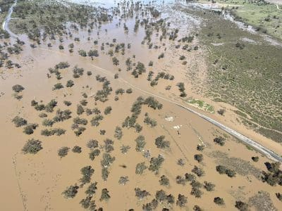
Major flooding is occurring at Forbes. As of 8am AEDT Thursday, the Lachlan River was at 10.68 meters with the possibility of reaching 10.80 meters later today. The river level may remain high into the weekend due to large inflows and releases from Wyangala Dam.
The Lachlan River at Forbes Iron Bridge remains steady at 10.68 meters as a prolonged peak passes through. The Lachlan River at Forbes Iron Bridge is expected to remain around 10.70 meters during Friday as the prolonged flood peak passes through. The river level is expected to remain above the major flood level (10.55 m) during the weekend.
Major flooding is occurring at Condobolin, Nanami, Euabalong, Warren, Hay, Barham, Boundary Bend, Bourke, Brewarrina, Hillston, Jemalong, Mungindi, Walgett and Wee Waa. Moderate flooding is occurring at Cowra and many other towns along the Murray River.
Major Flood Warnings are current for various locations in New South Wales and Victoria with major flooding occurring at numerous locations along the Murray River on the Victoria/New South Wales border.
Minor to moderate flooding is occurring across many other rivers in Queensland, New South Wales, Victoria and Tasmania.
 For the rest of today, isolated light showers will continue for parts of Tasmania, southern Victoria and south-east New South Wales with mostly dry conditions for inland parts of New South Wales, Victoria and South Australia.
Cold air from south of the country will maintain cool to cold temperatures through Tasmania, Victoria, New South Wales, south-east South Australia and some areas of inland Queensland.
The next rain bearing system will develop over eastern Western Australia today and will move into central Australia tomorrow, bringing showers and thunderstorms to eastern Western Australia, South Australia and southern Northern Territory.
This will strengthen into a cold front and move into the eastern states on Saturday, with northerly winds increasing ahead of the front across western New South Wales and Victoria.
Showers and thunderstorms will move through much of south-east Australia on Saturday and Sunday with most of the rain is expected to fall over Victoria and Tasmania.
On Monday, colder winds with widespread showers, possible hail and thunder are forecast for southern South Australia, Victoria, Tasmania and south-east New South Wales.
Source: BOM. Residents and communities living on or near any rivers, creeks, and streams or in low-lying areas should stay up to date with the latest forecasts and warnings via the BOM website and BOM Weather app and follow the advice of emergency services.