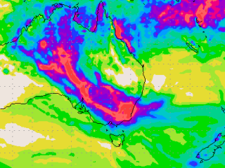
 The perfect recipe exists for heavy rain and flooding across large areas of Central and South Eastern Australia this week.
Senior forecaster with The Weather Channel, Tom Saunders, expects both areas to collectively soak through one of the biggest rainfall events in recent history.
Behind the forecasts are very warm ocean temperatures which currently surround the Australian continent, particularly off the west coast where the Indian Ocean has been steaming over 3C higher than normal during the past few months.
The warmer seas have increased evaporation which has allowed the atmosphere over Australia to become saturated with moisture – “the perfect recipe for heavy rain and flooding” Mr Saunders said.
“The drenching will start today over Victoria, South Australia and southern NSW where thunderstorms will drop up to 100mm of rain, enough to cause severe flash flooding, particularly in urban regions like Melbourne where drainage systems struggle to cope with intense rainfall," Mr Saunders said.
“River flooding is also likely and a flood watch is in force for all Victorian catchments except in East Gippsland and the South West.”
The rain and storms will head north on Tuesday and stall over NSW and central Australia until at least Friday.
Daily rain is expected to exceed 50mm in some regions, enough to cause flash flooding, but with rain continuing through the week weekly totals should easily climb above 100mm over much of southern and western NSW, northern SA and the southern NT. Canberra and Sydney's wettest days should be Wednesday and Thursday.
The rain also has the potential to trigger widespread river flooding through much of northern SA and NSW.
Meanwhile, after a wet few days in the tropics of Queensland, the region is in for another deluge this coming week.
In the 24-hours ending at 9am Sunday, torrential falls had already been recorded in places like Homebush in the Mackay region which has received 127mm, taking its two day rainfall totals to 181mm.
Sarina, also in the Mackay region has received 124mm also in the 23-hours to 9am while Mokowata, south-east of Gladstone picked up falls of 101mm during this time. Heavy rainfall was also recorded in places like Cardwell Range (81mm) and an area north of Cairns – Odonoghue Road (65mm).
“An area of high-pressure in the Tasman is generating a very moist and unstable onshore easterly airstream across eastern Queensland with the heaviest falls expected through central and north-eastern coastal regions,” says Felim Hanniffy of The Weather Channel.
Over the next four days from Sunday onwards, the coastal region of the northern tropics can expect to receive a further 100mm with isolated areas potentially recording falls of up to 150mm.