THE Bureau of Meteorology has defended its long-range forecasting after a predicted hot and dry summer turned into widespread rain and flooding.
From as early as March last year, BOM had been warning that Australia was heading towards an El Nino-influenced dry period – a forecast that was reported extensively by media outlets across the country.
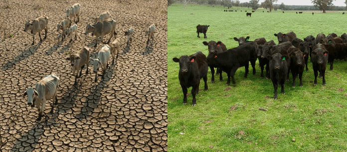
With parts of New South Wales and Queensland already experiencing a dry start to the year, the forecast was followed by large-scale destocking and a subsequent market crash.
Some have told Beef Central the forecast triggered the crash, while others have defended the agency saying it is up to producers to better interpret the forecast. (read the full article here)
Asked about how the dry forecast turned into a wet summer, the bureau said the impacts of El Nino were evident in the traditionally dry spring period.
“August to October was the driest such period on record for Australia, with very warm temperatures. September 2023 was the driest September on record and the second driest month ever on record,” a spokesperson said.
“Impacts from the record low rainfall and above-average temperatures through September and October included extensive fires across northern Australia including large parts of WA, the NT and Qld. Very low to extremely low soil moisture levels prevailed across most of Australia until late spring, when heavy rainfall and persistent humid conditions occurred across much of eastern Australia.”
The spokesperson said BOM issued a long-range outlook for summer in late November, which reflected the likelihood of rain.
“The Bureau’s long-range forecasts for summer, issued on 23 November 2023, indicated neutral to increased likelihood of above average rainfall across much of the continent for December and January, and increased likelihood of below average rainfall for the northern tropics,” the spokesperson said.
“The Bureau specifically advised, via its October 2023 to April 2024 severe weather season outlook, the ever-present possibility of cyclones and to expect a typical summertime risk of severe thunderstorms, and risk of riverine flooding.”
Was messaging the issue?
BOM’s messaging has also come under criticism in the past year, with the dry forecast represented in maps coloured with brown from coast to coast painting a bleak picture. Its maps were put in news articles that used terms like “Super El Nino” – a phrase not used by BOM.
In the comments section on Beef Central’s article last week, many pointed the finger at BOM while others said media outlets had as much to answer for.
Beef Central asked BOM if it was planning to review its messaging, what it thought of the media coverage and whether it took any responsibility for the media coverage, given the extensive airtime it is afforded.
This article will be updated if there is a response.
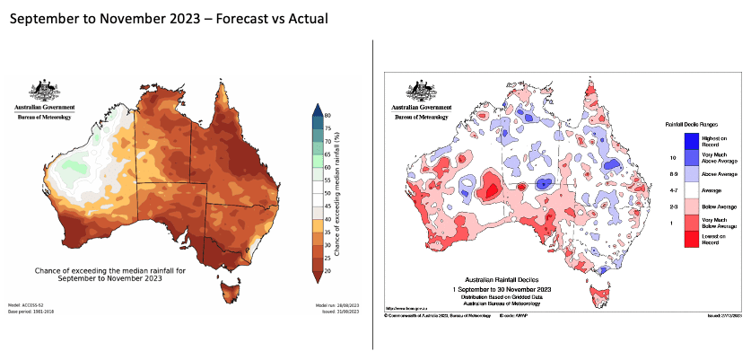
An example of the brown used in BOM’s forecasts
Unusual activity triggered rain last year
BOM’s spokesperson said last year’s rain in the usually dry El Nino period was driven by some unusual factors.
“The presence of a positive Southern Annular Mode (SAM), combined with very high temperatures in the Tasman Sea, likely contributed to rainfall events in eastern Australia in December and January,” the spokesperson said.
“It is unusual to see a persistently positive SAM during El Niño, as that is more typical during a La Niña phase. The widespread and regular rainfall across southeastern Australia across multiple months is similarly unusual for El Niño.
“No two El Niño and IOD events are the same and their impact on Australia varies. This is why the Bureau doesn’t simply rely on climate drivers but uses a wide range of inputs to create its outlooks, which are updated every fortnight and which provide details about when and where rainfall and temperature are likely to vary from the average.
“This is particularly true of summer months. Now that the northern monsoon has arrived, the influence of both El Niño and a positive IOD is diminished, and the chance of summer rainfall events increases. Around half of the past El Niño events have included heavy rainfall events, particularly across parts of eastern Australia. This occurred in December 2009 and again in August 2015 where the Illawarra received more than 400mm in two days.”
More rain could come this summer
BOM said its summer outlook is indicating a higher than average chance of rainfall large parts of the eastern states.
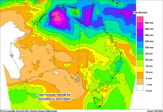
“The January to March long-range forecast, issued 4 January 2024, indicates an increased chance of above median rainfall for parts of southeast Queensland, eastern NSW and Victoria, and more neutral rainfall chances over the interior and southern parts of the country,” the spokesperson said.
“Warmer days and nights are very likely for almost all of Australia with unusually warm daytime and night-time temperatures are at least two times more likely than usual.
BOM said its outlook favoured drier than average conditions for most of WA, the NT and northern parts of Qld – many of those areas are said to be in for a drenching this week as shown on the map below.
BOM defends accuracy of forecasts
On the accuracy of BOM’s forecasts the spokesperson said: “BOM’s forecast accuracy has consistently ranked in the top 5 in the world.
“The Bureau’s Australian weather model (ACCESS) ranks in the top 4 alongside the European Union, United Kingdom and United States. On a seasonal timescale, the Bureau’s system is recognised as one of the best in the world.
“The Bureau’s high forecast accuracy is made possible by advanced computing power, more and better observations, continually improved models and the ability to run a range of weather and climate simulations or ensemble models to increase accuracy and reliability. The Bureau’s expert scientists draw upon the latest science to produce its forecasts and warnings.
“Weather forecasts carry an inherent uncertainty that, on some occasions, results in forecasts deviating from the actual weather. Long range forecasts do not predict sudden severe weather events. Sudden severe weather events are forecast through our short-term forecasts and communicated through warnings on our website and through the BOM Weather app.”