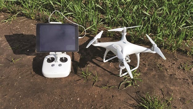
FARMERS, agricultural consultants and researchers have taken a great interest in drones over the past few years and agriculture continues to be one of the major growth sectors – fuelling the development and release of drone systems tailored specifically to agricultural applications.
The drone itself is simply a platform that offers particular advantages over other overhead imagery and sensing options, such as satellites and manned aircraft. The main advantages of drones are their relatively low cost to own and operate, and their ability to fly under clouds, and as often as required.
Before bringing drone technology into farm management, think about:
- The application
- The platform and accessories
The application
The biggest questions to answer are ‘What information do I want the drone to collect?’ and ‘What tasks do I want the drone to perform?’.
Most drones currently on the market come with standard cameras capable of capturing still images (digital photographs) and video footage in the visible light range. These drones can collect visually appealing footage for a range of uses such as routine inspections, checking for damage after floods, frosts or fire events and real estate. They can also find application in time and motion studies at critical times such as harvest and checking water troughs, fences, irrigation and livestock.
There are also opportunities to use these standard images to assess germination and determine plant density to assist with decisions such as whether to replant parts or a whole paddock. Crop scouting without entering the paddock can assist with several key decisions that a farmer or agronomist might make based on visual assessments of a crop.
These activities are potentially very informative and time saving, and can overcome constraints such as gaining access to paddocks immediately after rain or other weather events. These images can also be used in similar manner to handheld digital cameras to monitor and evaluate trials or seasonal effects on different varieties.
To use a drone to collect data that has additional value in terms of decision making and precision agriculture, the user may need to add other sensors to the drone platform. With the appropriate sensors on board, drones can be used for a wide variety of applications such as:
- Assessment of plant greenness or photosynthetic active biomass (which might correlate to nitrogen)
- Crop stress (for irrigation or other management)
- Weed stress (for fallow spraying)
- Insect activity (hot spots)
- Crop maturity or ripeness (for harvest or desiccation)
- Assessment of soil colour and ground cover
- Yield estimation
- 3D mapping for land levelling or development
For these applications to be possible the drone platform needs to be fitted with the correct sensors for the task and supported with the appropriate software to analyse the data collected.
There is now an obvious move toward the commercialisation of agricultural drones that include a package of hardware and software specifically tailored to agricultural industries. Early agricultural drone systems have also been brought to market by leading drone manufacturers to undertake a variety of tasks such as aerial spraying and seeding, bird scaring and water sampling.
The platform
There are four drone platforms commercially available currently, each with specific properties and uses in agriculture:
- Multi-rotor
- Fixed wing
- Single rotor
- Fixed wing hybrid
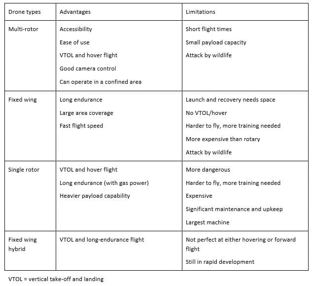
Source: Adapted from: Andrew Chapman, www.auav.com.au/articles/
Sensors and software for interpreting drone data
Flying a drone to make crop, livestock and infrastructure inspections is quite easy and relatively inexpensive.
If you want to use the drone to carry data-collecting sensors to create maps and make management decisions you will need to ensure that you have a drone platform that is physically capable of carrying the necessary equipment, have access to data and image processing software (either purchasing the software or subscribing to a service) and have the ability to transfer the maps to a variable rate applicator.
The software identifies and matches reference points in each photo and ‘stitches’ the images together to produce one, seamless image of the area or paddock of interest, viewed from directly overhead. If a flight takes 20 minutes and the camera is pre-set to take an image every 5 seconds of flight time this will result in 240 photos to process. Further analysis of the recorded data may be possible to extract specific information required for decision making.
With agriculture seen as a growth sector for drone technology, there are an increasing number of drone systems coming onto the market that offer a range of applications suited to agricultural management and decision making. Prominent brands currently offering agricultural drone systems include AgEagle, DJI (Agras) and Precision Hawk.
In some situations, it may be more cost-effective to engage the services of a specialist drone service to collect and interpret the data required.
Payloads
In addition to standard cameras, some platforms can carry one or two payloads and many allow the operator to swap payloads, meaning the platform can potentially carry out a number of different tasks using:
- multi-spectral sensor for crop monitoring (egNDVI)
- 3D photogrammetry cameras
- thermal imagery cameras (e.g. insect hot spots)
- dry material spreader (e.g. pellets, seed, fertiliser)
- water sampling
- bird scarer
- sprayer (liquid pesticide, fertiliser or herbicide).
When deciding which drone platform to purchase, be sure to research the practicality and costs involved in retro-fitting additional sensors. Be clear about what you want to be able to do with the drone now and try to envisage future applications.
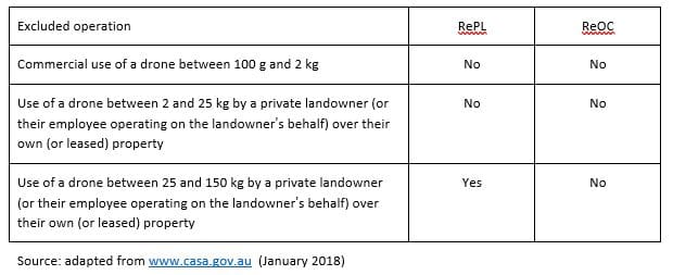
Rules and regulations for operating a drone
If you are operating a drone under 2 kg, or up to 25 kg on your own property, for commercial purposes, you might not need to be licensed and certified. However, you do need to:
1. Apply to CASA for an aviation reference number;
2. Tell CASA before you fly (valid for 24 months if you are flying in the same location);
3. Fly within the standard operating conditions;
4. Download the ‘Can I fly there’ app.
To operate a drone weighing over 2 kg for commercial purposes in locations other than your own property, or to operate outside the standard operating conditions, the operator must obtain a remote pilot licence (RePL) and an RPA operator’s certificate (ReOC).
Under the ‘landowner rule’, a drone (RPA) may be used for activities defined in regulation 101.237 (CASR, 1998), specifically:
- aerial spotting
- aerial photography
- agricultural operations (e.g. weed spraying, pest spraying, fertiliser application, seed broadcasting or application of other substances for agricultural purposes)
- aerial communications re-transmission
- carriage of cargo
- any other activity similar to those listed above
Standard operating conditions (SOC) apply to drone operations where the operator is using the ‘excluded operation’ category or flying recreationally. The SOC for drones (RPA) are summarised below:
- The drone is operated:
- by visual line of sight (VLOS) only
- no higher than 120 m above ground level
- during daytime only – not after sunset
- The drone is not operated:
- any closer than 30 m from people not associated with the flight
- in a prohibited area or restricted area
- in a restricted area that is classified as RA3
- over populated areas
- within 5.5 km (3 NM) of a controlled aerodrome – one with an operating control tower
- in the area of a public safety operation without the approval of a person in charge of the operation
- Only 1 RPA flown per pilot at any one time.
Refer: CASR Part 101 consolidates the rules governing all unmanned aeronautical activities into one body of legislation. Part 101 can be found in volume 3 of the Civil Aviation Safety Regulations 1998. Sub-part 101-F relates specifically to remotely piloted aircraft.
AC 101-10 Remotely piloted aircraft systems – operation of excluded RPA (other than model aircraft) https://www.casa.gov.au/files/ac10110pdf
https://www.casa.gov.au/drones
……………………………………..
Case study 1 – Using drone-acquired imagery to manage a high biomass crop
Bradley Donald, B&W Moree, Elders Rural Services, NSW
In 2016, a paddock of Commander barley near Moree, NSW was assessed as having high yield potential. Nevertheless at growth stage 30, areas of crop within the paddock were seen starting to lodge. Applying a growth regulator to the crop was a good option to reduce the lodging, but applying the full rate to the entire crop was considered unwarranted and expensive at $30/ha.
Agronomist Brad Donald, estimated that applying a growth regulant to prevent lodging in the high crop biomass areas could potentially increase yields by 0.5 t/ha and, with barley worth $200/t, this would generate an additional $100/ha.
Persistent cloud cover at the time prevented the use of satellite NDVI imagery. Instead, Brad generated an approximation NDVI map of the paddock using 700 images collected using a modified Canon S100 camera with a near Infrared (NIR)/blue/green lens that filters out the NIR wavelengths, mounted on an AgEagle fixed wing drone. The images were stitched together using offline Agisoft Photoscan software then georeferenced to fit the coordinates of the 128 ha paddock. Georeferencing is the process of assigning real-world coordinates to each pixel of the digital image. These coordinates are often obtained by collecting coordinates with a GPS device for few easily identifiable features in the image. Using these sample coordinates, or ground control points (GCPs), the image is warped to fit the area being surveyed.
SMS Advanced Mapping software was then used to estimate the NDVI of each pixel in the composite image, highlighting the high biomass zones (Figure 1), which were the areas of the crop at risk of lodging and amounted to 72 ha. Field inspection confirmed that the areas of highest biomass in the paddock were also identified on the map as areas with NDVI ≥ 0.43.
From the drone image, Brad produced the variable rate (VR) prescription spray map (Figure 2), which was loaded into the spray unit controller and used to apply the growth regulant. By varying the water rate of the spray unit, the high biomass zones (green) were sprayed at the full rate of Moddus Evo® (400 mL/ha) with a water volume of 80 L/ha, and the remainder of the paddock (red) received half the rate by lowering the water volume to 40 L/ha.
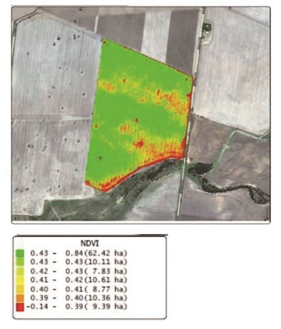
Figure 1. NDVI-approximation map generated from 700 images taken with a drone-mounted camera using an NIR/B/G lens that filters out the NIR wavelengths to show variability in crop biomass.
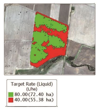
Figure 2. Spray application map showing high (80 L/ha, green) and low (40 L/ha, red) application rate zones.
The result was a reduction in cost of the product and increased yield due to a reduction of lodging. Additional un-costed, but significant, benefits in this case from the application of growth regulant included ease of harvest and improved stubble management for the next season.
The advantages of using a drone in this instance were:
- Rapid capture of images, which were unavailable from other sources due to cloud cover.
- Timely processing of images and critical decision-making.
- Making observations at a time when the paddock was untrafficable due to wet conditions.
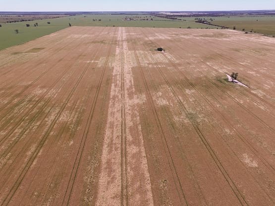 Figure 1. This paddock of Commander barley near Moree was sprayed with two different rates of growth regulant Moddus Evo to avoid yield losses to lodging. A strip down the centre of the paddock was left unsprayed and clearly stands out in this photo, showing a much greater level of crop lodging than the rest of the paddock.
Case study 2 – Using a drone to manage herbicide resistant weed patches
Mark Branson, Branson Farms, Stockport, SA
Crop and livestock farmer, Mark Branson has added a drone to his precision agriculture toolbox, specifically targeting patches of herbicide resistant weeds. Mark has chosen to use a DJI Phantom 4 (4-rotor / quadcopter) with its standard high resolution digital camera to monitor weeds during the crop season.
Early in the crop growth Mark is able to assess the weed pressure in a paddock using images that show individual plants that are 3 cm in diameter or wider, growing between the crop rows. Mark can use these images to generate a VRT map so he can target the surviving weeds with more expensive herbicides.
Once the canopy closes over, Mark uses the drone to spot weeds that are growing above the crop. Wild oats is of particular concern and seedheads can be seen very clearly in the drone images. Depending on the area of infestation, Mark will either bale the affected area for hay or consider spraying out larger areas of the crop as a last resort to prevent the weeds from setting seed.
Mark flies the drone himself, following a flight path that provides even coverage of the paddock. He then uploads the images to a cloud-based service provider. The images are ‘stitched’ together and a digital data map is returned to Mark, which he can upload to his tractor’s GPS monitor.
The same maps can then be used the following season to increase the seeding rate in the weedy areas to increase early crop competition to apply pressure to any new germinations of weeds.
Rather than analysing the images himself, Mark has purchased a subscription to ‘Drone Deploy’ services. This subscription service provides more accurate maps than the free service and saves Mark a considerable amount of time.
To use the cloud-based service requires access to NBN wireless or equivalent internet upload speeds.
In addition to using the drone to manage weeds, Mark has also found value in spotting mistakes or misses after spreading urea or seeding. Early detection means there is more opportunity to correct any mistakes.
Source: Society of Precision Agriculture Australia (SPAA)
This case study was supported by SPAA through funding from the South Australian Grain Industry Trust Fund as part of project SPAA118 – Conversations with Farmers: Agricultural Practice Change with the “PA-Early Adopters”
Produced by AgCommunicators P/L and Lightning Designs
More case studies available from SPAA website: www.spaa.com.au
Terminology: Drone = Unmanned aerial vehicle (UAV) = Remotely piloted aircraft (RPA)
The regulatory body in Australia, Civil Aviation Safety Authority (CASA), uses the term ‘drone’, however, there is a move toward the use of the term ‘remotely piloted aircraft’