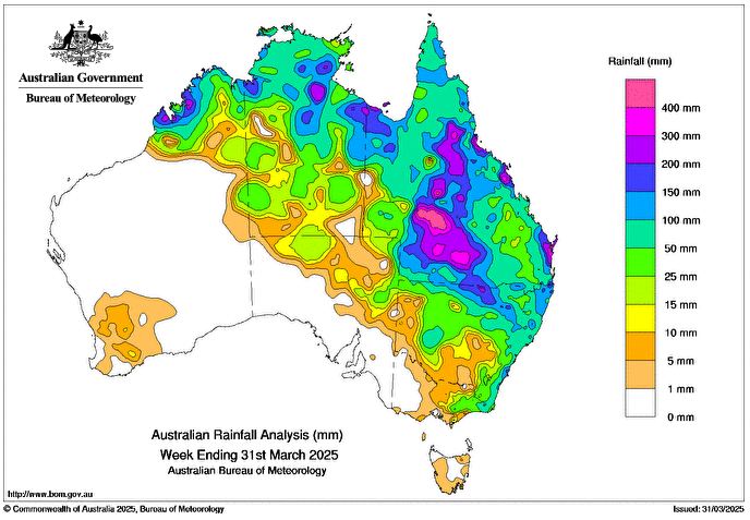
AN inland trough, upper disturbance and moist air generated persistent, widespread heavy rainfall over parts of the coastal, western and southern interior Queensland and northern New South Wales over the week.
Weekly rainfall totals of 200-500mm were recorded over a large area of western Queensland, exceeding the annual average in some areas.
Weekly rainfall totals of 50-200mm, locally higher, were recorded from the system across most of the rest of Queensland, the north of the Northern Territory and in northern New South Wales.
There was minor to major flooding across multiple catchments, including Cooper Creek in western Queensland.
Tropical Cyclone (TC) Dianne (28U) crossed the northern Kimberley coast around 2:30am AWST on 29 March and continued as an ex-TC in a south-easterly direction across Western Australia’s Northern Interior and western Northern Territory bringing rainfall to areas along its track.
Weekly rainfall totals of 100-200mm were recorded in the northern Kimberley, and 25-50mm was record in northern inland areas of Western Australia and south-eastern regions of the Northern Territory.
A low-pressure system developed off the New South Wales coast bringing rainfall to the coast from 29 March.
Weekly rainfall totals of 15-50mm were recorded across scattered New South Wales coastal regions with up to 150mm in isolated regions.
Weekly rainfall totals of 25-50mm were recorded across scattered regions of northern and eastern Australia.
The highest weekly total (at a Bureau gauge) was 602mm at Sunbury in Queensland, which includes the highest daily total of 347mm in the 24 hours to 9am on 27 March.