
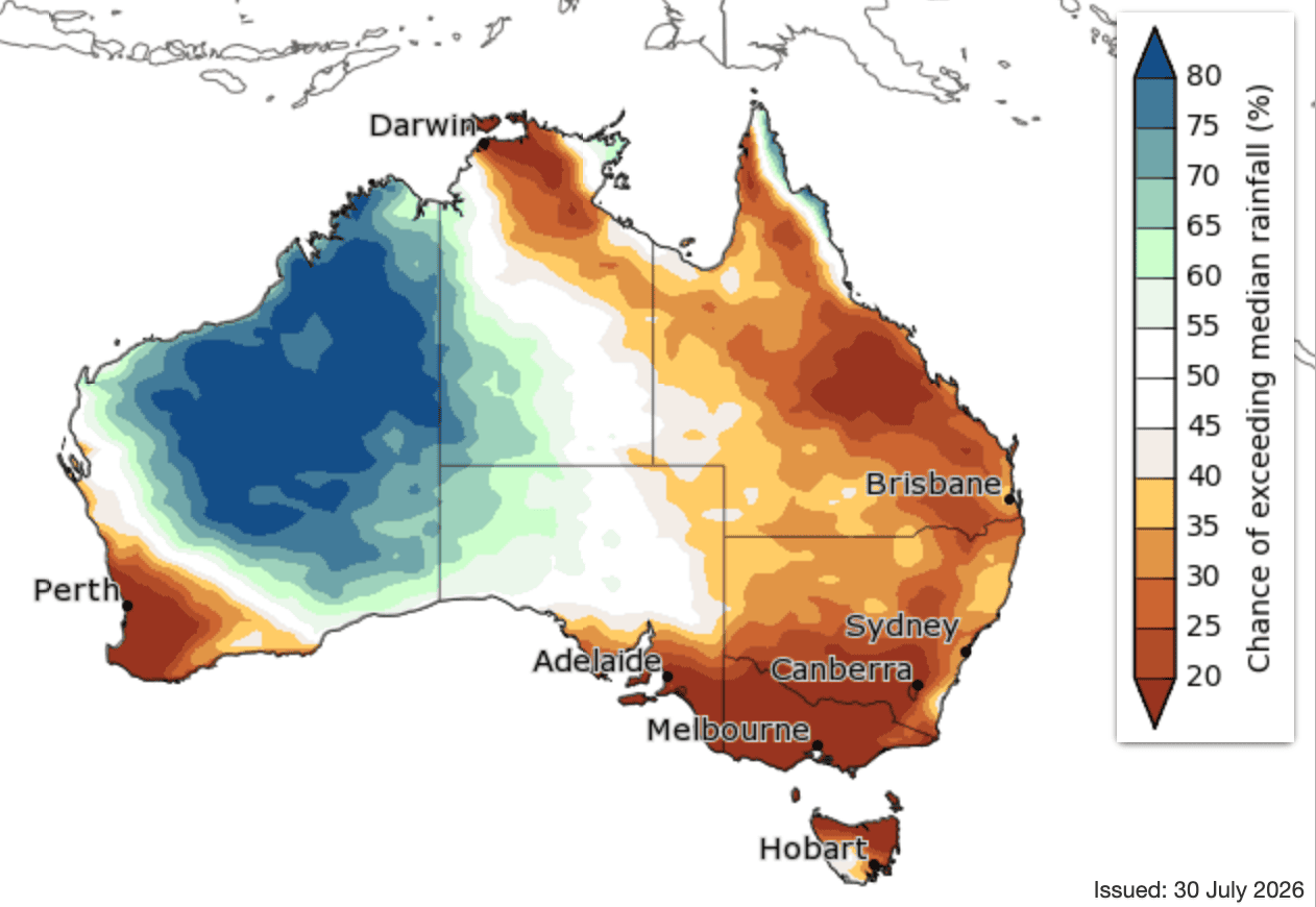
The three month outlook for August to October published earlier this year.
IF you looked at the above map earlier this year and expected a dry Spring across the Eastern Seaboard, than you should have known that it is still giving 20-40 percent chance of exceeding the median rainfall.
That is the message from the Bureau of Meteorology, who was defending its three-month outlook after a 60-80pc chance of below average rainfall turned into the wettest October on record for some parts of Queensland.
In the outlook published at the end of July, BOM was correct for August and September which were both well below average before the rain came in October. As the below map suggests, it was more accurate in parts of the country like Victoria, New South Wales and Western Australia.
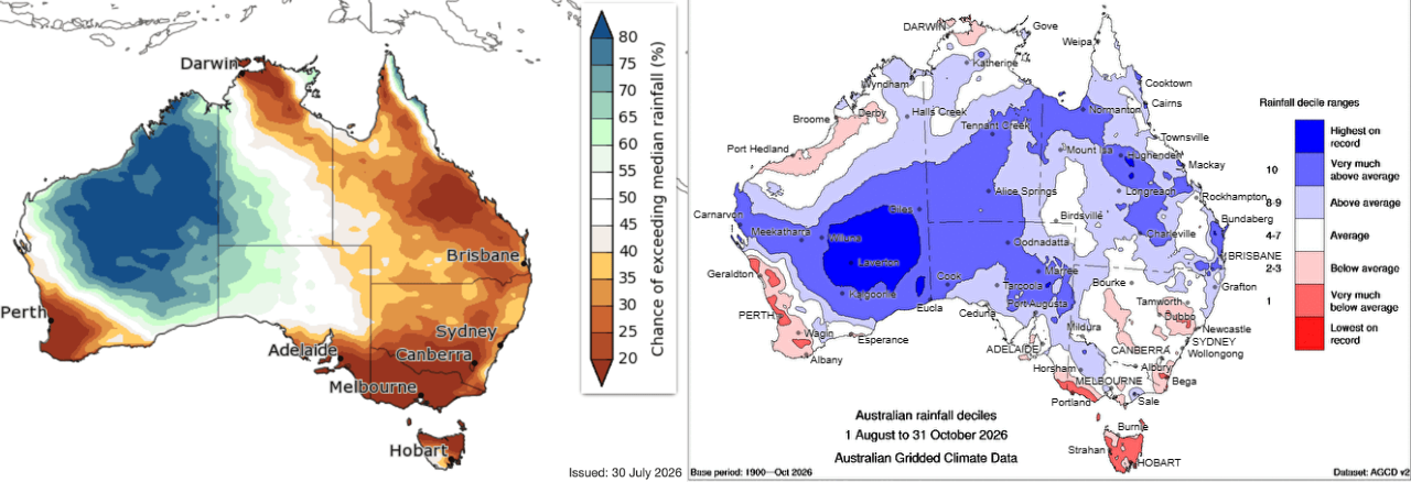
Asked about the discrepancy between the forecast and the outcome in Qld and Northern NSW, a Bureau spokesperson said:
“Long-range forecasts are not intended to predict individual short term weather events, that may produce significant rain in only a few days, these cannot be forecast weeks in advance. As a result, the eventual seasonal outcome can be significantly influenced by short-term high impact weather events that occur during the forecast period,” the spokesperson said.
“We saw this in October, as wetter conditions were the result of a series of significant high rainfall weather systems bringing more than double the typical October rainfall to much of Queensland.”
40-60pc of the outcome not detected by outlook models
BOM says that at least 40-60pc of the eventual outcome is determined by weather variability at a resolution that long-range models “cannot capture months or even weeks in advance.”
It uses a model called ACCESS-S, which it says is based on the latest science and draws on the latest global observations to make forecasts, with the monthly and seasonal forecasts updated weekly as conditions evolve.
 “Long-range forecasts are designed to support risk-based decision-making and preparedness, alongside shorter-range forecasts, and warnings as individual weather events approach,” the spokesperson said.
BOM was asked why it continues to publish the three-month outlooks when its models have such a high chance of getting it wrong. A spokesperson said:
“While a long-range forecast can miss the mark for a particular area or season, verification shows long-range forecasts get it right more often than not. They provide a better basis for planning than climatology, particularly when used alongside other information and decision-making tools.
“The value of long-range forecasts lies in helping users recognise when there is a shift in the broader seasonal climate patterns that may favour certain outcomes, such as drier than average conditions. They offer early insight into the broader climate context in which those events occur. ”
What value did this outlook provide?
The private sector is well and truly into weather forecasting, with dozens of free and subscription-based services interpreting the models and giving their thoughts on what they will mean for the weather in the future.
Beef Central was today shown a forecast from a subscription-based service which was gave its subscribers a six month warning that the October/November rain was coming. The same service has also been telling its subscribers that El Nino is more of a 2027 issue and was likely to be offset by Spring rain many areas have seen in the past month.
These issues came up in 2023, when an El Nino was declared, the brown maps were published and many areas had rain in Spring. Many blamed the forecast for a cattle market crash that year saying it pushed a lot of producers to sell their cattle.
BOM was also asked whether it accepted that the communication its outlooks is an issue.
“The bureau’s Agriculture Section are consistently engaging with farmers and farming groups across the industry and provide guidance on using the long-range forecast and the importance of regular updates.
“We encourage users to regularly check the long-range forecasts, as weather and climate systems constantly evolve.”
The impact of El Nino and positive IOD
Asked when the El Nino weather system is likely to start influencing the weather, the BOM spokesperson said:
“For eastern Australia, its influence on rainfall is typically most evident through winter and spring, when El Nino tends to increase the likelihood of drier-than-average conditions.
“That doesn’t mean every winter or spring during El Nino will be dry, or that significant rain events cannot occur. Individual weather systems still determine when and where rain falls.
“A positive Indian Ocean Dipole event is also now underway which is also likely to contribute to our climate patterns in the coming months.”
The outlook for the coming months is more positive than the Spring outlook and the BOM spokesperson said:
“The increased chance of above-average rainfall is influenced by a combination of warmer ocean temperatures, longer-term climate trends and natural year to year variability.
“Oceans around Australia and globally are much warmer than usual and this increases atmospheric moisture and energy that can fuel rain systems. Waters around Australia are forecast to continue warming in the coming months.”
HAVE YOUR SAY