
Warming seas suggest El Niño is on the horizon. dmytrok/Flickr
WITH forecast maps covered in brown and phrases like “godzilla El Nino” dominating headlines in recent weeks, there is plenty of talk about a dry season ahead.
The reporting has been striking a similar tone to 2023, when terms like “super El Nino” dominated discussions, dry weather was forecast and the cattle market spectacularly crashed. Many blamed the crash on the sensationalist reporting of the weather, as a large part of the Eastern Seaboard came into a good season at the end of the year.
 While this year’s El Nino has been tipped to be the strongest of its kind, there is plenty of conflicting information over the likelihood of rain to keep coming over in the next few months.
Weather apps and websites outside the Bureau of Meteorology have been rising in popularity and there is plenty of discussion about what the weather models are actually saying.
The Week in Beef podcast has been discussing the forecasts over the past fortnight, interviewing two producers who have taken completely different directions in their approaches to gathering information on the weather.
South Australian producer Tim Burvill has been a fierce critic of BOM in recent years and has decided to rely on sources outside the bureau to inform his management.
While Queensland producer Vicki Mayne has been working closely with BOM to better understand the forecasts and help communicate them to the industry.
Vicki Mayne
No one climate driver dances alone
Ms Mayne is a Climate Mate with the Northern Australian Climate Program, which is run by the University of Southern Queensland and funded by Meat & Livestock Australia and the Queensland Government. Her role is to support producers to interpret forecasts for on-farm decisions.
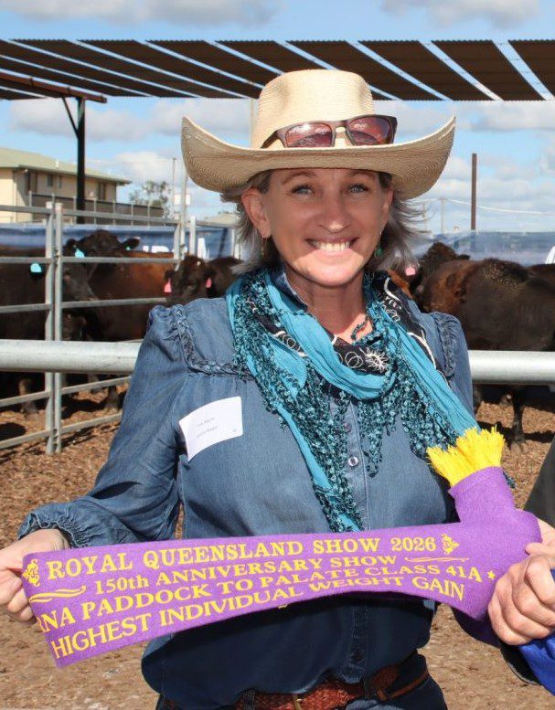
Cattle producer and Climate Mate Vicki Mayne.
She said while an El Niño has been declared, there is other information producers should consider when assessing the season ahead.
“It’s important to understand that El Niño does not automatically mean drought,” she said.
“No one climate driver dances alone. It can shift the odds, but it’s important to look at the full range of climate signals and what they mean locally. It’s about planning ahead and reviewing your strategies based on changing risk.”
Ms Mayne said the other big climate driver to watch out for is the Indian Ocean Dipole.
“The El Niño Southern Oscillation develops in the Pacific Ocean, while the IOD occurs in the Indian Ocean and typically influences winter and spring rainfall before decaying in December due to the Australian monsoon typically disrupting and weakening the IOD pattern,” she said.
“A positive IOD can enhance an El Niño event, but there is uncertainty in current model outlooks, with the IOD potentially developing as positive however it may remain neutral or become negative. It’s one to pay attention to.”
She said shorter-term drivers such as the Southern Annular Mode also play a role.
“The SAM influences conditions on a weekly basis and is currently contributing to some moisture in parts of Australia, but it’s a shorter-term driver that needs to be monitored regularly.”
(Check out Vicki’s interview on the below podcast at 10:30)
Some better maps to look at
One of the most prominent maps used to reflect BOM’s three-month rainfall outlook is the “chance of above median rainfall” map – which is typically covered in brown when dry weather is forecast.
“I am not a fan of the chance of above medium maps, it looks daunting when you see the brown but that brown still means there’s still a 20pc or a 35pc chance of exceeding median rainfall,” Ms Mayne said.
“The one I really like is the rainfall scenario maps, and that gives you a 75pc chance of how many millimetres of rain you are likely then to get.”
Ms Mayne said while there are challenges to communicating the weather at times, she believed BOM was still providing good information.
“We need to put a little bit of faith into our national agency, they are leading experts and they are working with other world meteorological agencies. They are using a lot of other agencies there and they have done the hard yards for us,” she said.
“What we need to do is produce this is just learn which of those forecast maps on our on the climate outlook pages is going to better suit us for management decisions.”
Tim Burvill
Catastrophic forecasts not having as much impact
While frustrated at the sensationalist El Nino reporting, Mr Burvill said he was sensing producers were moving away from a reliance on BOM for weather information – as the cattle market was heading in the opposite direction to 2023.
“The benchmark index of the cattle industry, the Australian Eastern Young Cattle Indicator (EYCI) recent just busted through 1000c/kg for the first time since mid-November 2022,” he said.
“The last time it was at this level it was falling through 1000c/kg and that was off the back of a forecast from the BOM about an impending terrible drought that was coming.”
Mr Burvill said he now uses a weather forecasting website called Meteologix, which presents models from across the world.
“When you start looking at it over a period of time, you will start to pick up a few trends,” he said.
“Firstly, I never would lock in rainfall unless it is agreed on quite a few models for the next seven-day period – once that happens, you know that the rain is coming.”
Mr Burvill said he only starts to think about rain close to the event.
“You can start seeing systems appearing on some of the models and they will appear before others. That can give you a bit more confidence that something is coming,”
“Once it gets to seven days, it is locked in. 10 days is when you might start to get excited and look at a few different models, and hopefully the rainfall event is showing up on a few different models, and that will give you a bit more confidence about what is happening.”
(Tim’s interview 17:12)
Call for BOM to adjust the way they present forecasts
Mr Burvill said he felt like the common response to criticism from BOM has been to tell farmers they are interpreting the forecasts incorrectly.
“I would suggest if we are all not smart enough to interpret their forecasts correctly, then perhaps they need to adjust the way they present them,” he said.
“A map covered in dark brown supposedly doesn’t mean that there is less likelihood of rain. And a forecast of 95pc chance of 10-20mm doesn’t mean you’re pretty much certain to get 10-20mm of rain.
“If they forecast only a 20pc chance of above median rainfall for the next three months, and we get flooding rains they can still claim they were right. Using this strategy, any forecast they make is correct. Farmers have had enough of hearing that nonsense.”
BOM should be paid on performance …
In which case they’d earn very little…
And they’d probably leave …
Doubt we’d be any worse off as farmers who must survive on our performance eh?
My view as a cattle producer is don’t rely on the BOM, they have not got it right for so long now.
Deal with what’s in front of you in the moment, meaning what feed have I got right now, is there enough to get me through the next 3-6 months or whatever you are comfortable with, have a destock plan or a feeding plan if that’s your thing, and have a running budget that keeps forecasting ahead that helps you get to a decision early. There are some great tools out there to help us make confident decisions at the right time. Be able to make hay while the sun shines but also be able to go on holidays when times are tough.
Let’s focus on the maps
No for casting there job s
Don’t depend on it
Save the 100 million and get on with the business of living one day at a time
Poor for casting costs a lot of people pain for no reason
The world needs truth
Looking at the warming bs
Just sent Australia a trillion dollars to the wall
Trillion reasons why the science is wrong wrong wrong