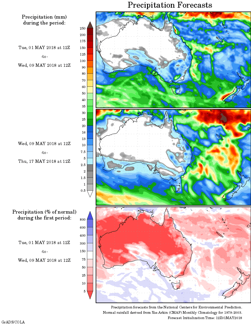
For today’s 14-day rainfall outlook – scroll to bottom of article
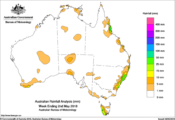
A SERIES of weak cold fronts tracked across southern Australia, and generated moderate falls in western Tasmania. A surface trough and offshore low pressure system produced moderate falls along the New South Wales coast.
Past seven days: In the first half of the week, a large cloudband with embedded thunderstorms extended through the interior of the continent to southeast Australia. This feature was associated with a surface cold front and an upper level trough, and produced light falls over parts of the agricultural and southeastern districts of South Australia, and southwest Victoria. Moderate falls were reported in western Tasmania.
A surface trough and an embedded low pressure system located off the northeastern New South Wales coast produced showers and thunderstorms during the first half of the week, with moderate falls recorded along the coast from the northeast to central coast New South Wales.
During the second half of the week, a middle level cloudband with isolated thunderstorms stretched from central Western Australia to the south of Tasmania. This feature produced very light rainfall in the central interior and south coast of Western Australia, the southwest coast of South Australia and western Tasmania. In the east, onshore winds coupled with a weak upper level trough generated thunderstorms and showers east of the Great Dividing Range in New South Wales, with localised heavier falls in the northeast of the State. A moist, onshore flow also produced showers about the north tropical and southeast Queensland coasts at the end of the week.
Rainfall totals in excess of 100 mm were recorded in isolated locations from the northeastern to central coast of New South Wales, including the highest total of 232 mm at Careys Peak (Barrington Tops).
Rainfall totals in excess of 50 mm were recorded in parts of the Mid North Coast, Northern Rivers and Hunter districts of New South Wales.
Rainfall totals between 10 mm and 50 mm were recorded in areas of the north tropical, central, and southeast coasts of Queensland; in New South Wales east of the Great Dividing Range from Moruya Heads northwards; in western Tasmania; an area of southwest South Australia between Ceduna and Yalata; and the southwest coast of Western Australia around Albany.
Little or no rainfall was recorded in most of Western Australia, the Northern Territory, Victoria, South Australia away from the southwest and parts of the agricultural districts, central and eastern Tasmania, New South Wales west of the Great Dividing Range, and most of Queensland apart from pockets along the east coast.
Highest weekly totals
New South Wales and Australian Capital Territory
232 mm Careys Peak (Barrington Tops)
149 mm Yarras (Mount Seaview)
135 mm Ballina Airport AWS
Victoria
10 mm Colac Airport
8 mm Boonah
7 mm Multiple locations
Queensland
41 mm Point Lookout
32 mm Byfield Childs Road, Bambaroo
Western Australia
9 mm Manypeaks
8 mm Tjukayirla
7 mm Ongerup, Denmark, Northcliffe
South Australia
14 mm North Adelaide
13 mm Cultana (Defence)
10 mm Nundroo
Tasmania
51 mm Mount Read
40 mm Queenstown (South Queenstown)
35 mm Lake Margaret Power Station
Northern Territory
6 mm Sunshine Bore
5 mm Black Point
3 mm Croker Island Airport
More weekly rainfall totals:
- NSW/ACT totals click here
- Vic totals click here
- Qld totals click here
- WA totals click here
- SA totals click here
- Tas totals click here
- NT totals click here
Source: BOM
14 Day rainfall outlook: