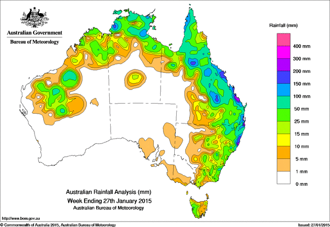
Rainfall recorded across Australia for the seven days to yesterday.
Rainfall totals in excess of 200 mm were recorded in parts of Queensland’s east coast south of Rockhampton and on the Gold Coast, and locations on New South Wales’ northern and central coast. The highest weekly total was 366 mm at Port Macquarie Airport in New South Wales.
Rainfall totals of between 50 mm and 200 mm were recorded in much of the Top End of the Northern Territory and between the Cape York Peninsula and northeastern New South Wales. Isolated spots in and south of the Kimberley in Western Australia, East Gippsland in Victoria, and on the west coast of Tasmania also recorded weekly rainfall totals above 50 mm.
Rainfall totals between 10 mm and 50 mm surrounded areas of higher falls and were also recorded in the Kimberley, Pilbara and Goldfields districts in Western Australia, the north of the Northern Territory, northern and southeastern Queensland, eastern to central New South Wales and parts of eastern Victoria and western Tasmania.
During the week a slow-moving low pressure system developed over southwestern Queensland in a surface trough lying through eastern Australia. An unstable moist airmass to the east of the trough and onshore flow combined with the low to produce thunderstorms and heavy showers in eastern to central Queensland and northeastern New South Wales. Extremely heavy falls were observed in southeastern Queensland during the event, with flood warnings issued for rivers on the east coast and as far west as Birdsville and Bedourie as water travelled downstream . Flash flooding also occurred in the Brisbane metropolitan area and on New South Wales’ north and central coast.
The southward extension of the surface trough and an approaching cold front later in the week also brought showers to the east of Victoria, central to eastern New South Wales and western Tasmania.
Elsewhere in northern Australia, the trough extended into the interior of the Northern Territory and into Western Australia later in the week, combining with onshore flow to bring thunderstorms and showers to the Top End early in the week and more broadly between the northern interior of Western Australia and the Cape York Peninsula in Queensland later in the week.
South Australia, most of Western Australia, the southern half of the Northern Territory and the west of the eastern States recorded little or no rainfall for the week.
Highest weekly totals in each state:
| State | Highest | 2nd Highest | 3rd Highest |
|---|---|---|---|
| WA | Theda (181 mm) (North Kimberley) |
Wiluna (60 mm) (Northeast) |
Bedford Downs Airstrip (54 mm) (East Kimberley) |
| NT | Shoal Bay (204 mm) (Darwin-Daly) |
Gunn Point (192 mm) (Darwin-Daly) |
Dum In Mirrie Airstrip (157 mm) (Darwin-Daly) |
| SA | Hallett (14 mm) (Lower North) |
Wudinna Aero (6 mm) (Western Agricultural) |
Price (6 mm) (West Central) |
| Qld | Burleigh Waters Alert (354 mm) (Moreton) |
Nerang Gilston Rd (297 mm) (Moreton) |
Seventeen Seventy (274 mm) (Port Curtis) |
| NSW/ACT | Port Macquarie Airport (366 mm) (Manning) |
Bowra Sugarloaf (280 mm) (Lower North Coast) |
Abbotsford (259 mm) (Metropolitan) |
| Vic | Genoa (Fools Haven) (57 mm) (East Gippsland) |
Wodonga (47 mm) (Lower Northeast) |
Mount Buller (45 mm) (Upper Northeast) |
| Tas | Mount Read (63 mm) (West Coast) |
Queenstown (43 mm) (West Coast) |
Lake Margaret (38 mm) (West Coast) |
Source: BOM


HAVE YOUR SAY