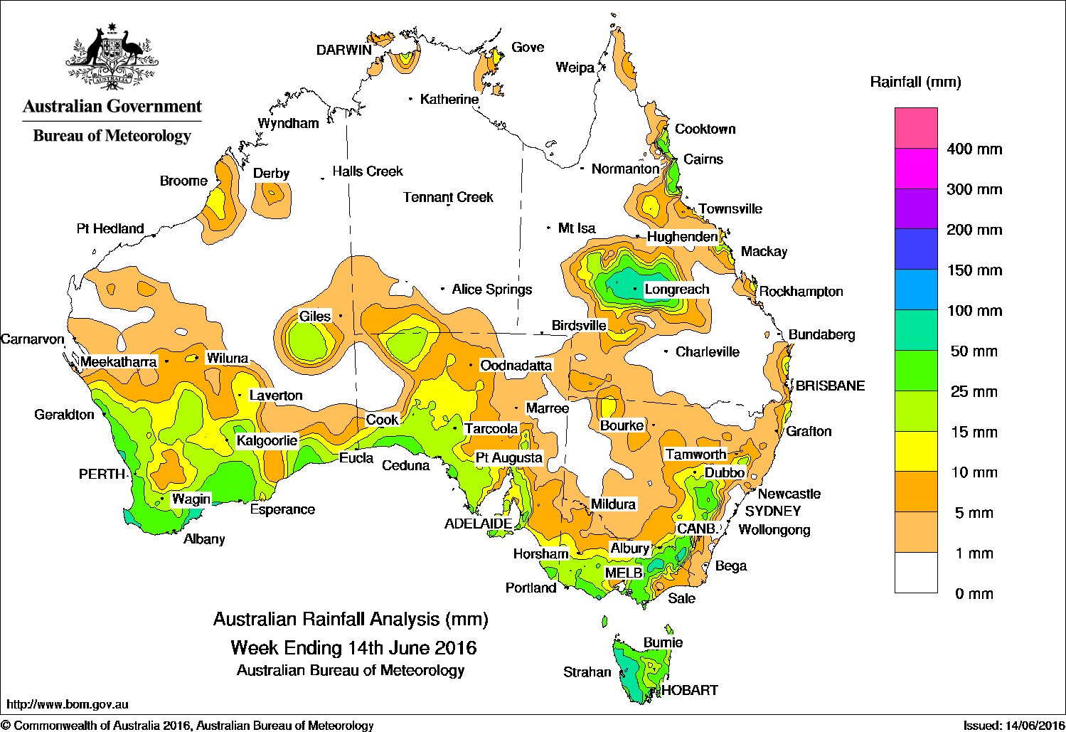
Rainfall in the past week was recorded mostly in the southern half of Australia, but there were also some excellent falls in Queensland’s central west.
At the start of the week, low pressure systems were located over the southern Tasman Sea and produced moderate rainfall totals in eastern and southern Tasmania.
A strong cold front moved through the southern part of Western Australia and South Australia. An associated low pressure system tracking along the southern coastlines of the continent, produced light to moderate falls to the south and the interior of Western Australia, also northern and southern South Australia. The weakening front then tracked eastwards and produced moderate falls in southern Victoria as well as the Victorian Alps and Snowy Mountains, and across Tasmania.
In the middle of the week, a westerly flow with embedded weak cold fronts tracked across the Great Australian Bight and Bass Strait, bringing light to moderate falls to the southern parts of the continent, with heavier falls recorded in western Tasmania.
At the end of the week, a broad middle to high-level cloudband associated with a cold front moved across the west coast of Western Australia. The cloudband produced moderate falls for much of the South West Land Division and parts of the Gascoyne and Pilbara. An upper-level trough tracked slowly northeastwards across southwest Queensland, with a cloudband extending from the northwest to the southeast of the State. Embedded thunderstorms produced moderate rainfall totals around Longreach and in Queensland’s central west.
Rainfall totals between 50 and 100 mm were recorded in western Tasmania, coastal parts of southwest Western Australia, areas of southern central Victoria also parts of the Victorian Alps and the Snowy Mountains in New South Wales, and in Queensland’s central west. The highest weekly total was 146 mm at Mount Read in Tasmania.
Rainfall totals between 10 mm and 50 mm were recorded in the South West Land Division and west Kimberley in Western Australia, in central Australia and parts of the Northwest Pastoral district in South Australia. Similar totals were also recorded along the southern coast of South Australia including the Eyre and Yorke Peninsulas, Mount Lofty
Ranges and parts of the Flinders Ranges; most of Victoria except the northwest and East Gippsland, and parts of the New South Wales southern Tablelands. Totals between 10 mm to 50 mm were also reported in the central west and north tropical coast of Queensland, and in small pockets of the Top End.
Most of the Northern Territory, central and northern Western Australia, southeastern, northern and western parts of Queensland, western New South Wales, and parts of western and northeastern South Australia recorded little or no rainfall this week.
Highest weekly totals list and map
New South Wales and Australian Capital Territory
114 mm Perisher Valley AWS
101 mm Cabramurra Smhea AWS
64 mm Thredbo Village
Victoria
108 mm Mount Buller
105 mm Falls Creek (Rocky Valley)
90 mm Mount Hotham
Queensland
163 mm Tully Sugar Mill
88 mm Barcaldine Post Office
86 mm Evesham Station
Western Australia
89 mm Witchcliffe
78 mm Cowaramup
77 mm Lancelin
South Australia
59 mm Heathfield Works Depot
54 mm Piccadilly (Woodhouse), Aldgate
Tasmania
165 mm Taranna (Parks & Wildlife)
146 mm Mount Read
103 mm Queenstown (South Queenstown)
Northern Territory
16 mm Point Stuart
15 mm Gove Airport
13 mm Alcan Minesite
More weekly rainfall totals:
- NSW/ACT totals click here
- Vic totals click here
- Qld totals click here
- WA totals click here
- SA totals click here
- Tas totals click here
- NT totals click here
Source: BOM


HAVE YOUR SAY