Cold fronts tracked across southeast Australia, generating moderate to heavy localised falls, while onshore showers and thunderstorms produced moderate falls in the northern tropics.
Past seven days: At the start of the week, a broad convective cloudband stretched from central to southeast Australia due to a surface trough of low pressure interacting with an upper-level disturbance. The surface trough and an embedded low pressure system moved eastwards across western New South Wales and northern Victoria, and the upper-level trough deepened as it moved into eastern Victoria. The trough and low pressure system then moved southeast over Tasmania. These features produced widespread light to moderate falls over northern South Australia, southern parts of the Northern Territory, much of New South Wales, southwest Queensland, and much of Victoria and Tasmania. Onshore flow produced isolated showers and thunderstorms in northern Australia and the north tropical Queensland coast.
 By the middle of the week, a cold front and associated deep low pressure system moved across waters south of the Great Australian Bight. The vigorous cold font and a pre-frontal trough tracked across southeast Australia, extending north into southern parts of Queensland. Widespread moderate falls continued across southeastern Australia and extended into southern inland Queensland. Some areas reported locally heavier falls. Isolated showers and thunderstorms developed along a surface trough stretching from the Kimberley to the Top End and northern Queensland.
In the last part of the week, a strong, cold, southwesterly airstream swept over the southeast in the wake of the cold front, and brought moderate falls to southern and northeastern Victoria, elevated areas of the Snowy Mountains in New South Wales, and western and northern Tasmania. A surface trough extended across northern Australia and down the east coast, with showers and thunderstorms producing moderate falls in the Top End of the Northern Territory, the Cape York Peninsula and north tropical Queensland coast. Isolated showers and thunderstorms generated moderate falls to the Wide Bay and South East Coastal districts in Queensland.
A weak low pressure system and cold front, associated with the complex low to the south of Tasmania, developed to the State’s west and tracked across the southeast, with snow falling in elevated areas, and moderate falls to the west and north of Tasmania, and Alpine regions of Victoria and New South Wales. Showers developed along a surface trough located over the southwest coast of Western Australia, producing mainly light falls.
Tropical cyclone Harold developed in the Solomon Sea on the 1st and intensified while moving east-southeast to the south of the Solomon Islands. Severe tropical cyclone Harold made landfall on Vanuatu on the 6th as a category 5 storm producing very destructive winds and heavy rainfall to Solomon Islands and Vanuatu.
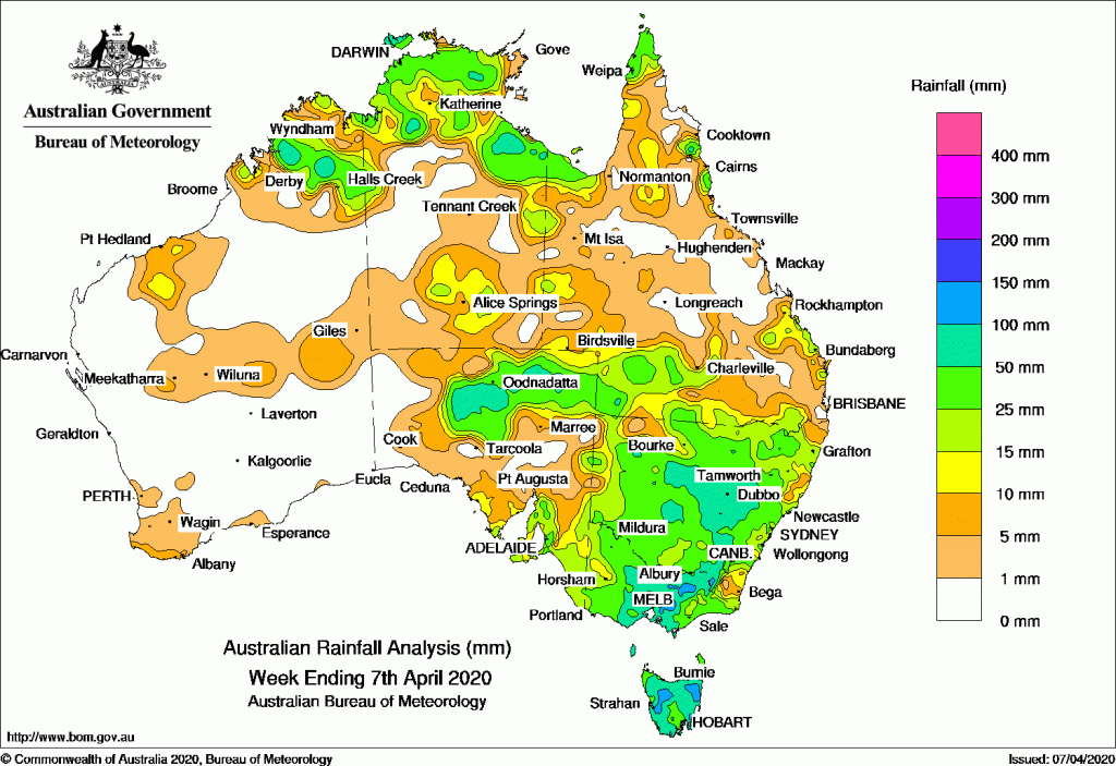
Rainfall totals in excess of 100 mm were recorded in parts of southern central and northeastern Victoria, in parts of western and northeastern Tasmania, and in small areas of the Northern Territory. The highest weekly total was 151 mm at Pirlangimpi Airport, on Melville Island in the Northern Territory.
Rainfall totals in excess of 50 mm were recorded in parts of the Kimberley, the north of the Northern Territory, northern parts of South Australia, through central to southeast inland New South Wales, central southern to northeastern Victoria and, most of Tasmania.
Rainfall totals between 10 mm and 50 mm were recorded remaining areas of the Kimberley; in the north and south of the Northern Territory; parts of northern, southern and east coast Queensland; most of New South Wales; northern, eastern and southern South Australia; most of Victoria: and remaining parts of Tasmania.
Highest Weekly Totals
New South Wales and Australian Capital Territory
145 mm Meldrum (Coolawarrah)
138 mm Old Bar (Ondarro Crest)
133 mm Yarras (Mount Seaview)
Victoria
18 mm Multiple locations
Queensland
297 mm Cowley Beach (Defence)
274 mm South Johnstone Exp Stn
271 mm Innisfail
Western Australia
16 mm Edjudina, Geraldton Town
15 mm Pemberton
South Australia
19 mm Kimba
18 mm Cowell (Winter Springs)
17 mm Buckleboo (Karinya)
Tasmania
43 mm Mount Read
41 mm Marrawah
39 mm Lake Margaret Dam, Erriba (Jubb Road)
Northern Territory
106 mm Ngayawili
89 mm Pirlangimpi Airport
80 mm Croker Island Airport
Rainfall outlook
![]()


HAVE YOUR SAY