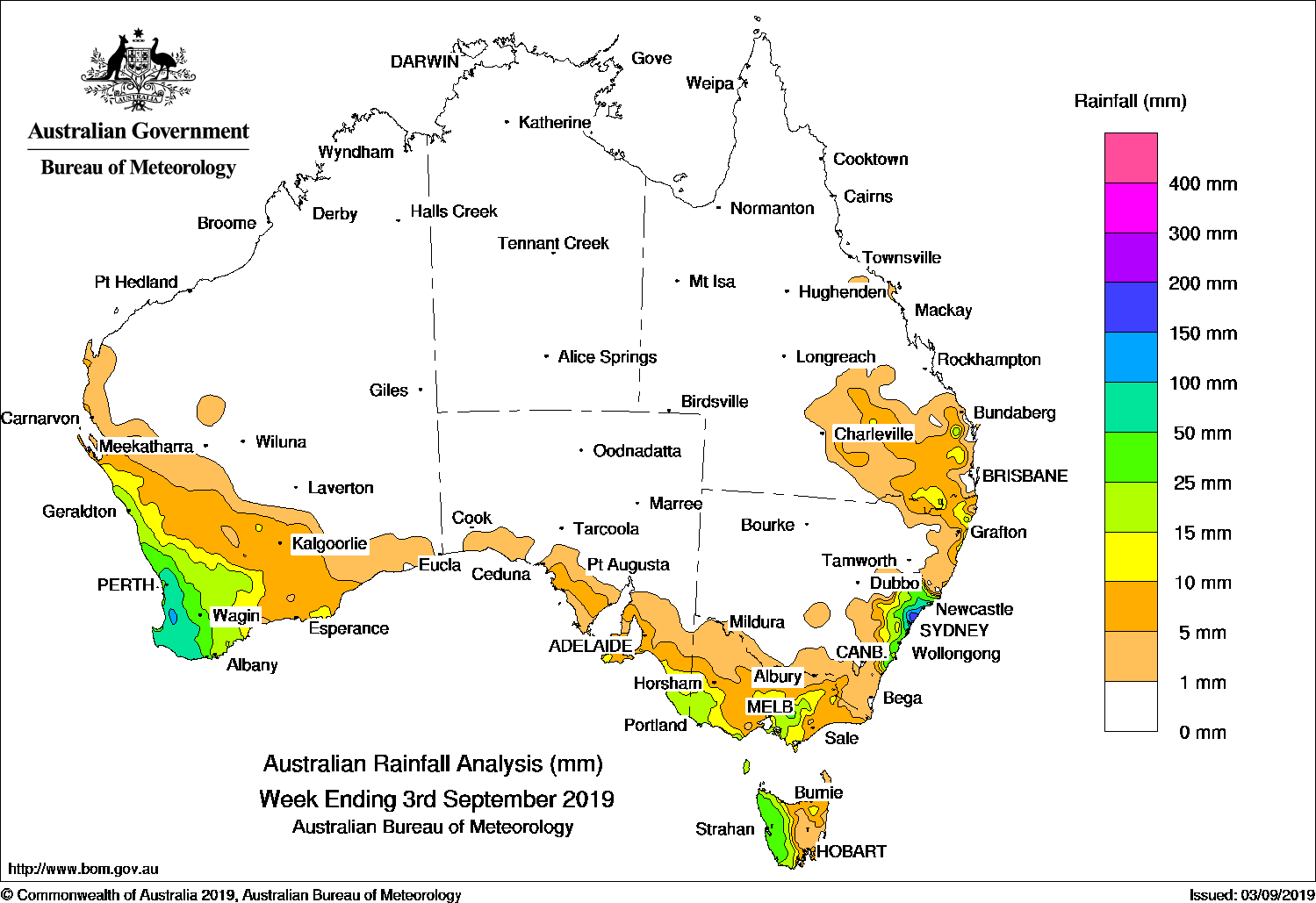
Cold fronts brought moderate falls to the southwest and southeast, while surface troughs and a low pressure system produced moderate to heavy falls along the central coast of New South Wales.
Past seven days: At the start of the week, a cold front tracked northeast across southeastern Australia, and brought widespread light falls to southeastern South Australia, Victoria and Tasmania, with moderate falls reported in southern central Victoria and western Tasmania. A surface trough stretching through inland Queensland to the central coast of New South Wales generated showers and isolated thunderstorms over northeastern New South Wales and southeast Queensland. A complex low pressure system developed along a trough located just off the east coast of New South Wales, with a second trough extending westwards over the coast. The systems produced thunderstorms and enhanced shower activity from the Hunter District to the South Coast District of New South Wales. Moderate to locally heavy falls were reported before the troughs and low weakened and tracked away from the coast by mid-week.
From the middle of the week, a pair of cold fronts with pre-frontal troughs approached and tracked across southwest Western Australia. Moderate falls were recorded across most of the west of the South West Land Division, and widespread light falls were reported in the southern Gascoyne, Goldfields, and Eucla districts in Western Australia. As the cold fronts tracked eastwards, light falls were recorded in southeastern South Australia, most of Victoria, the Snowy Mountains in New South Wales, and western Tasmania. Another pair of cold fronts crossed southwest Western Australia at the end of the week and brought light to moderate falls across the South West Land Division. As the fronts tracked eastwards, further light falls were reported in southeast Australia.
Rainfall totals in excess of 150 mm were recorded in parts of the Hunter District in New South Wales, including the highest weekly total of 216 mm at Swansea (Catherine St).
Rainfall totals exceeding 100 mm were recorded in an area of southwest Western Australia, and along the central coast of New South Wales.
Rainfall totals in excess of 50 mm were recorded in parts of the southwest coast of Western Australia from just north of Perth to Walpole, along the central coast of New South Wales, and a small area in western Tasmania.
Rainfall totals between 10 mm and 50 mm were observed in remaining parts of the South West Land Division in Western Australia; far southeastern South Australia; in the southwest and from southern central to northeastern Victoria; the western half and northeast of Tasmania; remaining areas in the central coast and adjacent inland districts, and northeastern New South Wales; and in parts of southeastern Queensland.
Little or no rainfall was recorded in remaining areas of Western Australia, the Northern Territory, South Australia away from the south coast, all of Queensland except in the southeast, New South Wales away from the coast, much of northwestern Victoria, and in southeastern Tasmania.
Highest weekly totals
New South Wales and Australian Capital Territory
216 mm Swansea (Catherine St)
205 mm Gosford AWS
197 mm Newcastle (Blacksmiths)
Victoria
29 mmMonbulk (Spring Road)
28 mm Mount Baw Baw
25 mm Balmoral (Post Office)
Queensland
35 mm Mount Joseph
29 mm Fraser Island, Eurong
22 mm Lindfield
Western Australia
122 mm Mount William
117 mm Mount Solus
116 mm Walpole Forestry
South Australia
21 mm RobeKingston SE
20 mm Robe Airfield, Cape Jaffa (The Limestone)
Tasmania
85 mm Mount Read
45 mm Zeehan
41 mm Lake Margaret Power Station, Queenstown (South Queenstown)
Northern Territory
0.2 mm Groote Eylandt Airport
Some elevated sites can be affected by snow and wind, and the true totals are most likely higher
Rainfall outlook:


HAVE YOUR SAY