Tropical cyclone Kimi developed east of Cairns and tracked towards the coast, bringing moderate to heavy falls to the north tropical Queensland coast, while a cold front brought moderate falls to southern Victoria and western Tasmania.
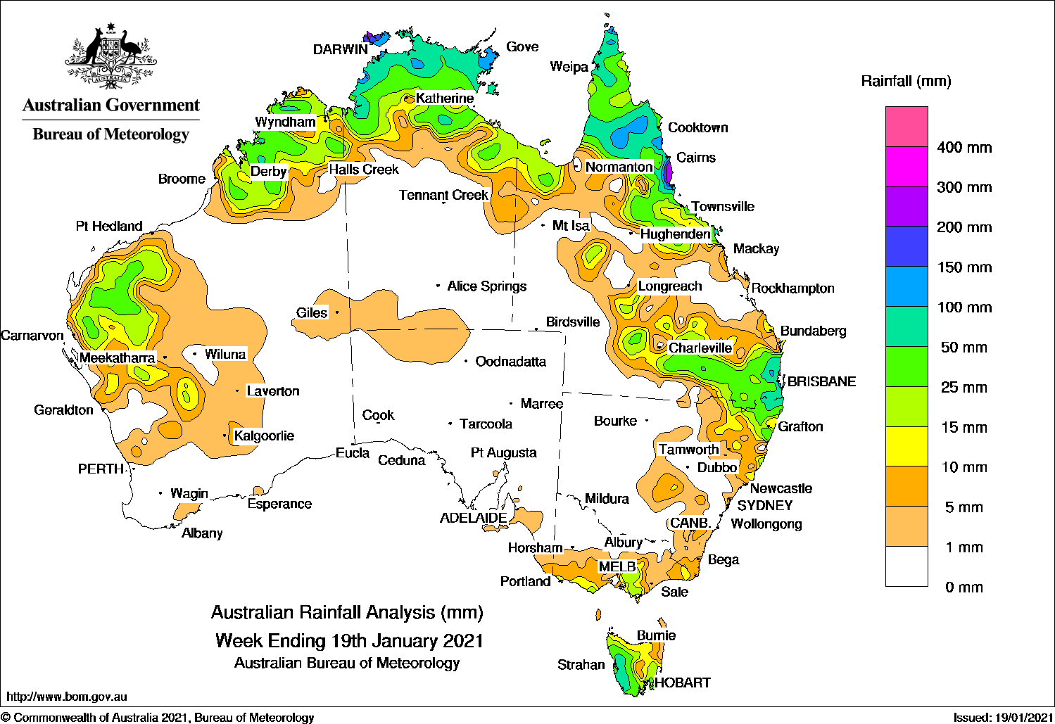
Past seven days: For the week to 19 January 2021, rainfall was recorded in Gascoyne, Pilbara and Kimberley in Western Australia, the Top End and Gulf Country in the Northern Territory, northern and central to south-east Queensland, north-eastern New South Wales, southern and far eastern Victoria, and most of Tasmania.
At the start of the week, a trough extended from the Cape York Peninsula down to the southern Coral Sea, with an embedded weak low pressure system off the north-east Queensland coast. Another trough extended from the western Top End through northern and central Western Australia. An active band of thunderstorms produced moderate falls over the Top End and the Cape York Peninsula, and on the north tropical coast of Queensland. A trough and associated cloudband moved across central New South Wales, eastern Victoria and Tasmania, and produced showers and mainly light falls in south-east New South Wales and across most of Tasmania.
In the middle of the week, a cold front tracked over Tasmania, and produced moderate falls in southern Victoria, and western and southern Tasmania. Snow was reported at Mount Buller in Victoria. A trough extending from southern inland Queensland to the central coast of New South Wales triggered showers and thunderstorms in south-east Queensland and north-east New South Wales. Surface troughs and low pressure systems extended down the north-west coast of Western Australia; also across the Top End and the Cape York Peninsula, generating moderate to heavy falls in the northern tropics.
The monsoon trough with embedded weak lows was located to the north of Australia, through the northern Gulf of Carpentaria to the Coral Sea, with enhanced convection and moderate to heavy falls recorded in Arnhem Land and the far tip of the Cape York Peninsula. Thunderstorms developed in the Gascoyne and Kimberley in Western Australia, the Top End and the north tropical coast of Queensland; also through the southern interior of that state.
In the last part of the week, the weak low east of Cairns intensified, and developed into tropical cyclone Kimi on the afternoon of 17 January 2021. The system generated moderate falls from Cooktown to Townsville, with heavier falls around Tully when tracking southward parallel to the north tropical coast. The system weakened from a category 1 system to a tropical low on the 19th.
Rainfall totals in excess of 200 mm were recorded in the north tropical coast of Queensland and the Darwin–Daly District and Arnhem Land in the Northern Territory. The highest weekly total was 369 mm at Babinda in north-east Queensland.
Rainfall totals in excess of 100 mm were recorded in some coastal parts of the Top End in the Northern Territory, areas of the Cape York Peninsula, and the north tropical coast of Queensland.
Rainfall totals between 10 mm and 50 mm were recorded in the Gascoyne, Pilbara and Kimberley in Western Australia, the Tope End and Gulf Country in the Northern Territory, the Cape York Peninsula, the north tropical Queensland coast and adjacent inland districts, from central to south-east Queensland, and north-east New South Wales. Similar totals were recorded in southern and far eastern Victoria, and most of Tasmania except the far north-east.
Highest weekly totals
New South Wales and Australian Capital Territory
118 mm Boat Harbour (Rous River)
108 mm Brays Creek (Misty Mountain)
91 mm North Murwillumbah (Tweed Rive
Victoria
36 mm Coldstream, Ferny Creek
27 mm Mount Baw Baw
Queensland
369 mm Babinda Post Office
314 mm Tully Sugar Mill
274 mm Bingil Bay
Western Australia
78 mm Windjana Gorge
60 mm Theda
51 mm Anna Plains, Gibb River
South Australia
10 mm Parawa (Second Valley Forest)
9 mm Mount Gambier Aero
7 mm Kuitpo Forest Reserve
Tasmania
113 mm Mount Read
82 mm Tasman Island
76 mm Lake Margaret Power Station
Northern Territory
226 mm Pirlangimpi Airport
222 mm Marrara
220 mm Csiro Berrimah
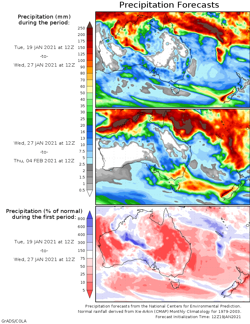
Rainfall outlook


HAVE YOUR SAY