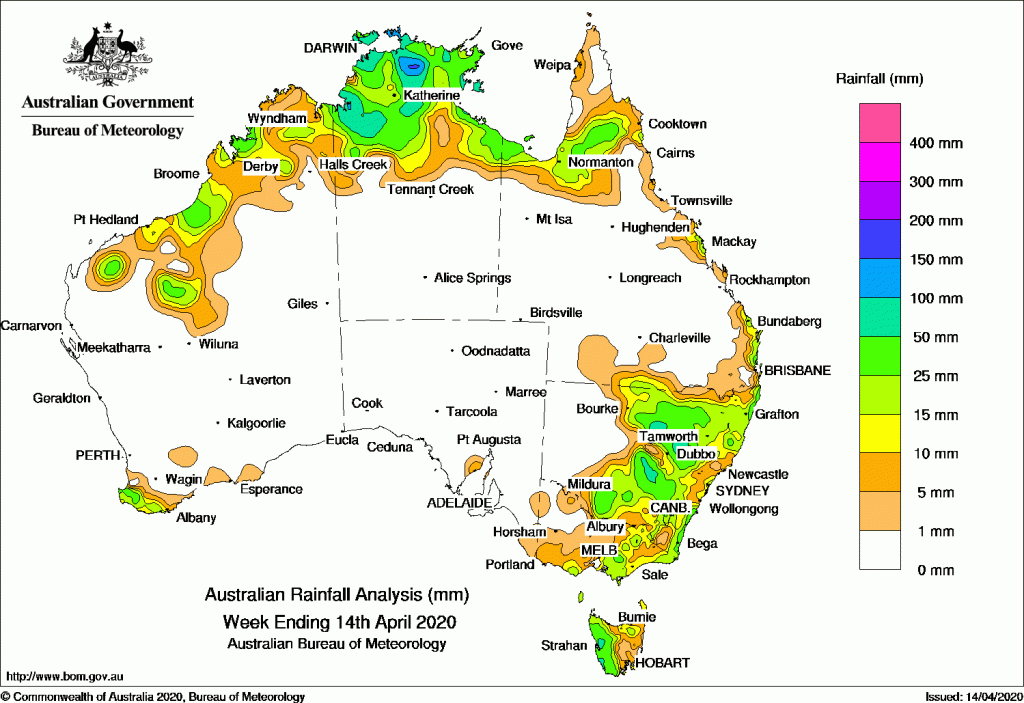
Past seven days: At the start of the week, showers and thunderstorms generated moderate falls over the Kimberley and Pilbara in Western Australia, the Top End in the Northern Territory and the southern Cape York Peninsula in Queensland. Onshore showers produced mainly light falls about the southeast coast of Queensland and along the east coast of New South Wales. A surface trough extended from the Gulf Country, down through western Queensland and western New South Wales, and deepened by mid-week. The surface trough interacted with an upper level disturbance, and generated widespread moderate falls in southern inland Queensland and across much of central to eastern New South Wales. A cold front and pre-frontal trough tracked across southwest Western Australia and brought moderate falls to the far southwest of that State.
Tropical convection continued to produce moderate falls across much of the Top End in the Northern Territory and parts of the Gulf Country to the middle of the week.
In the second half of the week, the cold front tracked across the Southern Ocean and then southeast Australia, and generated widespread light falls in eastern New South Wales, Victoria, and Tasmania. Moderate falls were reported in western Tasmania and northeastern New South Wales. Another cold front followed, and the cold southwesterly stream brought mainly light falls to western Tasmania, the eastern half of Victoria, and far southeastern New South Wales.
At the end of the week, showers and thunderstorms produced moderate falls across parts of the northwest coast of Western Australia and the coastal Top End of the Northern Territory. A moist, onshore flow brought showers and moderate falls to parts of the central coast of Queensland.
Rainfall totals in excess of 100 mm were recorded in small parts of the Top End in the Northern Territory, including the highest weekly total of 195 mm Bradshaw–Koolendong Valley.
Rainfall totals in excess of 50 mm were recorded in parts of the Top End in the Northern Territory, areas in the Central Western Slopes in New South Wales, and the west coast of Tasmania.
Rainfall totals between 10 mm and 50 mm were recorded in the Kimberley, Pilbara, and the far southwest of Western Australia; remaining parts of the northern half of the Northern Territory; parts of the Gulf Country, southern Cape York Peninsula, east coast and southern inland Queensland; most of central to eastern New South Wales; parts of southern, eastern and northeastern Victoria, and western and northeastern Tasmania.
Highest weekly totals
New South Wales and Australian Capital Territory
93 mm Quambone Station
79 mm Dunedoo (Shell)
77 mm Forbes Airport AWS
Victoria
52 mm Mallacoota
43 mm Mount Baw Baw
32 mm Balook
Queensland
66 mm Mackay Aero
54 mm Plane Creek Sugar Mill
45 mm Point Lookout
Western Australia
49 mm Busselton Aero
44 mm Cape Naturaliste
38 mm JarrahwoodPardoo Station
South Australia
5 mm Mount Gambier Aero
4 mm Pinnaroo
3 mm Mount Schank (Jethia)
Tasmania
92 mm Mount Read
60 mm Zeehan
49 mm Queenstown (South Queenstown)
Northern Territory
195 mm Bradshaw-Koolendong Valley
135 mm Central Arnhem Plateau
129 mm Croker Island Airport
Rainfall outlook
![]()


HAVE YOUR SAY