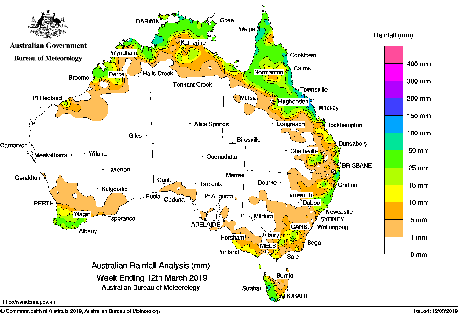
A series of cold fronts and troughs brought light to moderate falls to southwest and southeast Australia, while a surface and upper-level trough produced moderate falls in northern and eastern Queensland.
Past seven days: At the start of the week, a cold front and pre-frontal trough tracked across southeast Australia, generating light falls along parts of the south coast of South Australia, southern and eastern Victoria, western and southern Tasmania, and parts of central to southeastern New South Wales. As the frontal system approached the east coast of New South Wales, the system brought moderate falls to areas of the State’s central coast and southeast, along with further moderate falls in western Tasmania.

Isolated thunderstorms generated some moderate falls in parts of Arnhem Land, and coastal areas of the northwest and northern Top End in the Northern Territory.
A surface trough spanning the northwest to southern interior of Queensland, combined with an upper level disturbance and produced thunderstorms and showers over the north tropical to central coasts and adjacent inland districts in Queensland. Further showers and thunderstorms generated moderate falls along much of Queensland’s east coast, southern interior and Cape York Peninsula; also in northeastern New South Wales.
A cloudband associated with a trough and cold front tracking across southern Australia produced moderate falls in southwest Western Australia, and western and southern Tasmania during the middle of the week. A slow-moving upper level trough over the interior of Queensland continued to produce unstable conditions, with showers and storms producing moderate falls in parts of northern and eastern Queensland.
In the last part of the week, thunderstorms and showers developed over the Kimberley and east Pilbara coasts and areas of the Top End in the Northern Territory. Thunderstorms also formed near a surface trough located over northern New South Wales and brought moderate falls to parts of the northeastern and central coasts of the State. A number of weak cold fronts tracked over southeast Australia, generating mainly light falls in southeastern South Australia, southwest and northeastern Victoria, southeastern New South Wales and western Tasmania.
Rainfall totals in excess of 100 mm were recorded along the central coast of Queensland, including the highest weekly rainfall totals of 196 mm at Eton Vale.
Rainfall totals in excess of 50 mm were recorded in isolated spots of the Kimberley coast in Western Australia, small areas of the northwestern and northern Top End in the Northern Territory, coastal areas of the Cape York Peninsula, the north tropical to central coasts of Queensland, and a small area of western Tasmania.
Rainfall totals between 10 mm and 50 mm were recorded in the southwest and Kimberley and east Pilbara coasts in Western Australia, large areas of the Top End in the Northern Territory, the Gulf Country, northern and east coast Queensland as well as areas in the southeastern interior, northeastern and the central coast of New South Wales as well in elevated areas of the Snowy Mountains. Similar totals were recorded in southern central and northeastern Victoria, southeastern South Australia, and western and far southern parts of Tasmania.
Little or no rainfall was recorded in remaining parts of Western Australia; most of South Australia except the far southeast; the Northern Territory away from the Top End; western, central and southern inland Queensland; much of central to western New South Wales; northwestern Victoria and northern Tasmania.
Highest weekly totals
New South Wales and Australian Capital Territory
54 mm Boat Harbour (Rous River)
44 mm Murwillumbah (Bray Park)
43 mm North MurwillumbahBowra Sugarloaf
Victoria
26 mm Snowy River
24 mm Murderers Hill
21 mm Madalya
Queensland
125 mm South Johnstone Exp Stn
116 mm Tully Sugar Mill
111 mm Mt Sophia
Western Australia
67 mm El Questro
64 mm Kilto Station
46 mm Drysdale River Station
South Australia
5 mm Braemar
3 mm Cromer Road, Bower
Tasmania
9 mm Mount Wellington (The Springs)
5 mm Hobart (Strickland Reserve)
4 mm Maatsuyker Island Lighthouse
Northern Territory
135 mm Groote Eylandt Airport
129 mm Maningrida Airport
104 mm Port Keats Airport
More weekly rainfall totals:
- NSW/ACT totals click here
- Vic totals click here
- Qld totals click here
- WA totals click here
- SA totals click here
- Tas totals click here
- NT totals click here
Rainfall outlook:


HAVE YOUR SAY