For today’s 14-day rainfall outlook – scroll to bottom of article
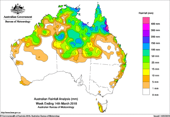
A monsoon trough and lingering surface trough near Cairns produced very heavy falls and flooding about the north tropical Queensland coast. A weak low pressure system located over the southern Gulf of Carpentaria produced moderate to heavy falls across northwestern Queensland and in the Northern Territory.
Past seven days: At the beginning of the week, a surface trough extended from the Kimberley in Western Australia, across the base of the Top End in the Northern Territory, through the Cape York Peninsula to a low pressure system in the Coral Sea. Another surface trough extended southward through inland Queensland from a low pressure centre embedded over the southern Gulf of Carpentaria. Several days of very heavy rainfall affected the north tropical Queensland coast, causing major flooding in the Herbert, Johnstone, Mulgrave, Russell, Tully and Murray rivers. A rainband producing widespread moderate to locally heavy falls also stretched from the Gulf, through inland Queensland to northeastern New South Wales.
As the low pressure centre in the Gulf of Carpentaria shifted slowly westwards and combined with a broad upper low over the Northern Territory, a moist and unstable air mass extended moderate rainfall totals over northern and western Queensland, and the east of the Northern Territory. By mid-week, widespread areas of rain and thunderstorms produced moderate falls across the southern half of the Northern Territory, parts of Arnhem Land, and in northwest and northern Queensland. Major flooding occurred at Walkers Bend on the Flinders River in the Gulf Country.
A ridge extending along the east coast produced showers in a moist onshore flow along the east coast of Queensland and northeastern New South Wales into the middle of the week as more tropical rain shifted westward.
During the last part of the week, the surface trough extended around the west coast of Western Australia, through the Kimberley and Top End, to meet the monsoon trough extending across the northern Cape York Peninsula. Thunderstorms and showers with moderate falls were recorded during the remainder of the week across parts of the Pilbara and Kimberley in Western Australia, the Top End of the Northern Territory, and the Cape York Peninsula.
A cold front brought a dry cool change to the southeast in the middle of the week, while the following west to southwesterly flow over Tasmania produced moderate falls in western Tasmania at the end of the week.
The highest weekly total was 844 mm at Greenhaven on the north tropical Queensland coast. Rainfall totals well in excess of 400 mm were recorded in the north tropical coast of Queensland between Cooktown and Cardwell. Areas around Burketown on the southern Gulf of Carpentaria coast in Queensland exceeded 200 mm.
Rainfall totals between 100 mm and 200 mm were recorded in parts of the south and northeast of the Northern Territory, about the Gulf Country and northern Cape York Peninsula, the north tropical Queensland coast and adjacent inland districts, and an area of the central coast of New South Wales.
Rainfall totals between 50 mm to 100 mm were recorded in isolated locations in the Pilbara in Western Australia, in parts of Arnhem Land and the southeast and southwest of the Northern Territory, most of the Gulf Country and northwestern Queensland, the Cape York Peninsula, and pockets of southeast Queensland and northeastern New South Wales.
Rainfall totals between 10 mm 50 mm were recorded in the Kimberley and eastern half of the Pilbara in Western Australia; most remaining parts of the Northern Territory; in western and southern Queensland; northeastern and much of coastal New South Wales, and in western Tasmania.
Little or no rainfall was recorded in Western Australia south of the Pilbara, in South Australia or Victoria, Tasmania away from the west coast, and New South Wales away from the east coast and northeast. Pockets of southwest and central Queensland, and an area in the inland northwest of the Northern Territory also received little rainfall for the week.
Highest weekly totals
New South Wales and Australian Capital Territory
166 mm Dorrigo (Old Coramba Rd)
150 mm Meldrum (Coolawarrah)
130 mm Kalang
Victoria
10 mm Preston Reservoir
5 mm Bundoora (Latrobe University)
4 mm Wallan (Kilmore Gap)
Queensland
844 mm Greenhaven
704 mm Tully Sugar Mill
686 mm Mt Sophia
Western Australia
66 mm Country Downs
52 mm Bonney Downs
45 mm Nita Downs
South Australia
29 mm Ernabella (Pukatja)
20 mm Mount Dare
4 mm Oodnadatta Airport, Kalamurina
Tasmania
39 mm Mount Read
20 mm Lake Margaret Power Station
18 mm Tim Shea (Summit)
Northern Territory
225 mm Kurundi
181 mm Alcan Minesite
136 mm Marqua, Ngayawili
More weekly rainfall totals:
- NSW/ACT totals click here
- Vic totals click here
- Qld totals click here
- WA totals click here
- SA totals click here
- Tas totals click here
- NT totals click here
Source: BOM


HAVE YOUR SAY