WHAT’S AHEAD? Scroll down to see today’s 14 day precipitation outlook
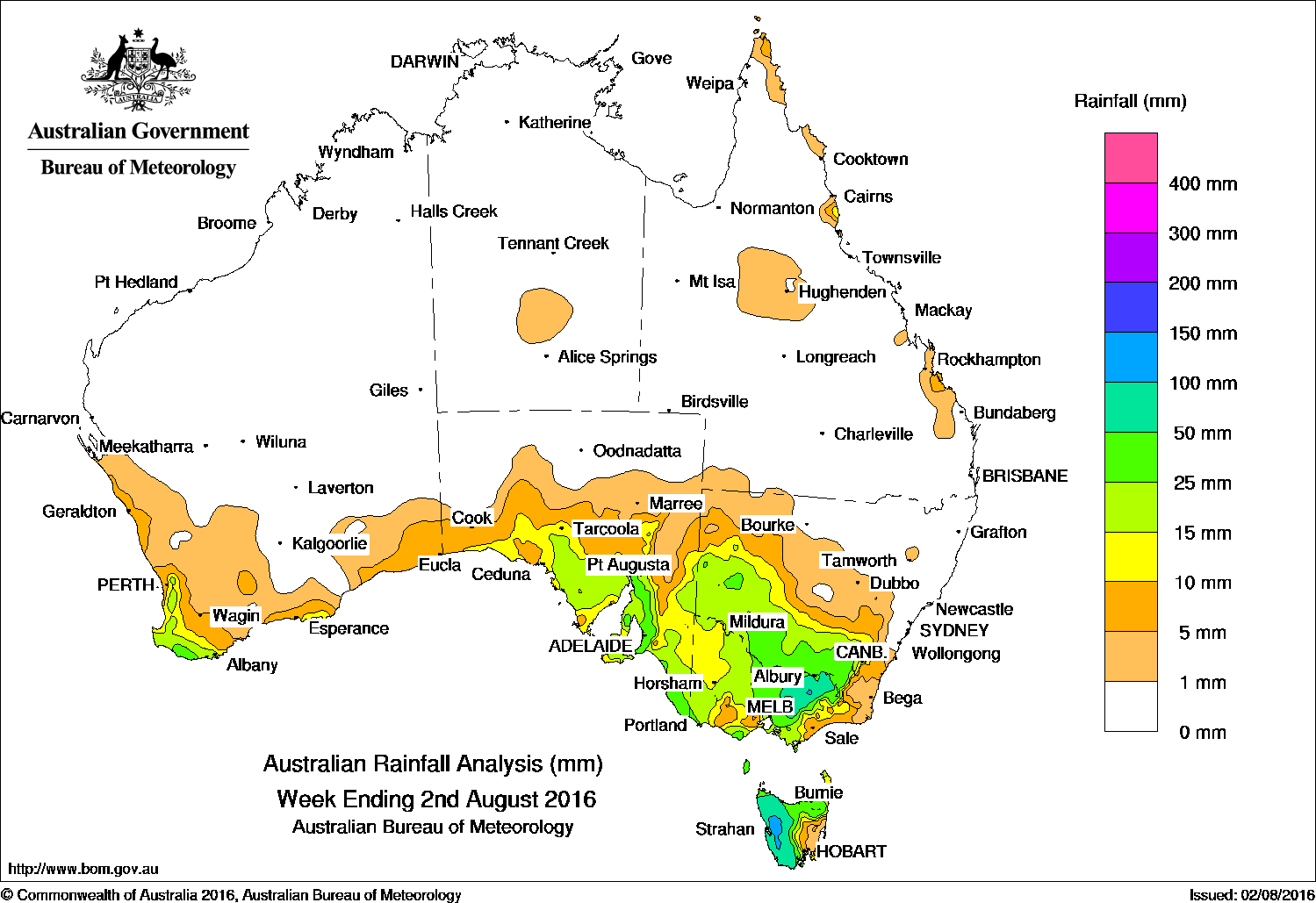
Victoria and South Australia received the best falls over the past week, with dry conditions in most other areas of the continent.
Past seven days: A cold front tracked across southeast Australia, with an associated low pressure system over Tasmania. Moderate rainfall was recorded in parts of south central and southeast South Australia, the Victorian Alps, the Snowy Mountains, and western and northern Tasmania.
In the middle of the week, a cold front and trough with an associated cloudband moved across the southern parts of the country. A second cold front with embedded thunderstorms approached southwest Western Australia. Light, widespread rainfall was recorded along the southern coast from Eucla to South Gippsland, and western Victoria. Moderate falls were recorded in southwest Western Australia and western Tasmania.
At the end of the week, the cold front tracked through South Australia and the southeast of the continent, and produced moderate falls in the Northwest Pastoral district and Mount Lofty Ranges in South Australia, western Tasmania, parts of central and northeast Victoria, and southern New South Wales.
A moist onshore flow produced light to moderate falls in the north tropical coast of Queensland during the week.
100mm plus: West Coast and Highlands regions in Western Tasmania, and in the Victorian Alps. The highest weekly total was 179 mm at Mount Read in Tasmania.
50-100mm: Most of the western half of Tasmania, and in parts of the Victoria Alps and the Snowy Mountains in New South Wales.
10-50mm: Southwest and parts of the southern coast of Western Australia, in the most southern parts of the agricultural districts of South Australia. Similar falls were recorded in the western and northeastern Victoria, southern New South Wales and northern Tasmania. A small area of Queensland’s north tropical coast recorded up to 20mm.
Little to no rainfall: The Northern Territory, most of Queensland, northern New South Wales and Western Australia away from the southeast and southern coast..
Highest weekly totals
New South Wales and Australian Capital Territory
47 mm Hume Reservoir
44 mm Perisher Valley AWS, Corowa Airport
Victoria
113 mm Falls Creek (Rocky Valley)
98 mm Mount Buller
97 mm Myrhee (Handcocks)
Queensland
28 mm Coconut Island
25 mm Innisfail
16 mm Bingil Bay
Western Australia
33 mm Shannon
28 mm Manjimup
27 mm Walpole Forestry, Dwellingup
South Australia
64 mm Uraidla
59 mm Piccadilly (Woodhouse)
58 mm Mount Compass, Uraidla (Sutton Creek), Ashton
Tasmania
179 mm Mount Read*
158 mm Lake Margaret Power Station
110 mm Warra
Northern Territory
1.4 mm Territory Grape Farm
0.2 mm Charles Point, Centre Island
*Mount Read was affected by snow and wind, and the true total is most likely higher.
More weekly rainfall totals:
- NSW/ACT totals click here
- Vic totals click here
- Qld totals click here
- WA totals click here
- SA totals click here
- Tas totals click here
- NT totals click here
Source: BOM


HAVE YOUR SAY