For today’s 14-day rainfall outlook – scroll to bottom of article
A vigorous cold front produced moderate falls across southeastern Australia at the start of the week. A cut-off low pressure system and cold front generated showers and thunderstorms in southeastern South Australia later in the week.
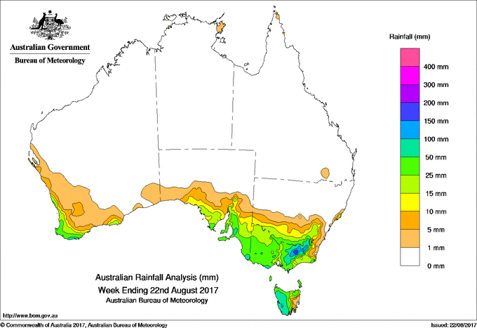
Past seven days: At the start of the week, a vigorous cold front and associated cloudband over southeastern Australia connected to a complex low pressure system to the south of the Bight, producing widespread moderate falls in southern South Australia, southern New South Wales, Victoria and western Tasmania, with higher totals about the Alps. Some minor flooding resulted about the Adelaide Hills district and Onkaparinga River while there were river rises in northeastern Victoria. A cold westerly flow in the wake of the cold front continued to produce moderate falls across southeastern South Australia, much of Victoria and western Tasmania until the middle of the week.
From the middle of the week, a cut-off low pressure system and associated cold front developed and slowly tracked across southwest Western Australia and generated moderate falls about Western Australia’s southwestern coastal fringe. In the east, a weak low pressure system and associated cold front crossed southern Victoria and Tasmania, while the complex low moved across the south of Tasmania and into the Tasman Sea, producing a cold, southwesterly flow. This brought mainly light falls to southwestern Tasmania, most of Victoria and elevated areas of southeastern New South Wales. Moderate falls were recorded in parts of central southern Victoria.
At the end of the week, the cut-off low pressure system had tracked into South Australia, with the centre near Adelaide. The system produced showers and thunderstorms about the Eyre and Yorke Peninsulas, Kangaroo Mountain and the Mount Lofty Ranges. Widespread, light falls were recorded across southern South Australia and western Victoria.
Rainfall totals in excess of 100 mm were recorded elevated areas of the Victorian Alps and the Snowy Mountains in New South Wales, and in a small area in western Tasmania. The highest weekly total was 240 mm at Perisher Valley in New South Wales.
Rainfall totals between 50 mm and 100 mm were recorded in the western half of Tasmania, northeastern Victoria, elevated areas in southeastern New South Wales. Similar totals were recorded in small areas of the South Coast district in Western Australia and in southeastern South Australia.
Rainfall totals between 10 mm and 50 mm were recorded in the South West Land Division in Western Australia, in South Australia south of a line from Ceduna to Loxton, Victoria, southern parts of New South Wales, and in the remainder of Tasmania except near the East Coast.
Little or no rainfall was recorded in remaining parts of Western Australia, the northern halves of South Australia and New South Wales, Queensland, and the Northern Territory.
Highest weekly totals
New South Wales and Australian Capital Territory
240 mm Perisher Valley AWS*
194 mm Thredbo Village*
104 mm Cabramurra AWS*
Victoria
213 mm Falls Creek (Rocky Valley)*
177 mm Mount Buller*
159 mm Falls Creek*
Queensland
2 mm Canungra Finch Road
1.8 mm Cape Moreton Lighthouse
1.6 mm Hamilton Island Airport
Western Australia
65 mm Yoongarillup
64 mm Walpole Forestry
63 mm North Walpole. Albany
South Australia
91 mm Mount Barker
90 mm Lobethal
89 mm Balhannah (Killara Park)
Tasmania
94 mm Warra
84 mm Mount Read*
83 mm Queenstown (South Queenstown)
Northern Territory
5 mm Charles Point, Gove Airport
0.4 mm Port Keats Airport, Centre Island, Ngukurr Airport
More weekly rainfall totals:
- NSW/ACT totals click here
- Vic totals click here
- Qld totals click here
- WA totals click here
- SA totals click here
- Tas totals click here
- NT totals click here
Source: BOM


HAVE YOUR SAY