Today’s 14-day rainfall outlook – scroll to bottom of article
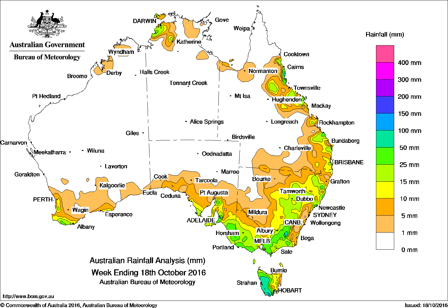
Rainfall was recorded in the past week in the northwestern Top End, the east coast of Queensland, eastern to central New South Wales, Victoria, Tasmania, southern parts of South Australia and southwest Western Australia.
Past seven days: At the start of the week, a cold front embedded in a westerly airstream tracked across Tasmania and Victoria. Moderate falls were recorded in western Tasmania, and light falls were reported across much of Victoria and southeastern New South Wales.
From the middle of the week, a number of weak cold fronts tracked across southwest Western Australia, while a cloudband associated with a pre-frontal trough developed and extended from the northwest of the continent to western Tasmania. Moderate falls were recorded in southwest Western Australia, along the southern coastline of South Australia, and in southwestern Tasmania. As this cloudband continued to track across South Australia, Victoria and Tasmania, another cloudband associated with the next cold front tracked from the eastern Bight and across the southeast at the end of the week. Between them, the cloudbands generated moderate falls across large parts of southeastern Australia at the end of the period.
A band of thunderstorms moved across southern Queensland and eastern New South Wales at the end of the week, associated with the first of the two cloudbands, generating moderate falls in southeast Queensland and northeastern New South Wales.
During the week, a moist onshore flow onto the east coast of Queensland and northern New South Wales produced moderate falls about the north tropical coast of Queensland and the mid-north coast of New South Wales.
A few showers and storms brought rainfall around Darwin in the Top End at the start of the week, and light falls across a larger area of the Top End at the end of the week.
50mm-100mm:Western Tasmania, pockets of the Snowy Mountains and Victorian Alps, the Mount Lofty Ranges in South Australia, and pockets of the north tropical coast of Queensland.
10mm-50mm: Southwest Western Australia, in southeastern South Australia and about the Yorke and Eyre Peninsulas, across most of Victoria except the Mallee and central north, and all of Tasmania apart from the northeast coast. Similar totals were recorded from central New South Wales to the centre of the Great Dividing Range and across northeastern New South Wales, along much of east coast of Queensland south of Cooktown, and in the Darwin–Daly region in the Top End of the Northern Territory.
Little or no rainfall: Western Australia except the southwest and southern coasts, most of the Northern Territory away from the Top End, northern, western and central Queensland, central and western New South Wales and the northeast coast of Tasmania.
Highest weekly totals list and map
New South Wales and Australian Capital Territory
96 mm Thredbo Village
87 mm Perisher Valley AWS
76 mm Thredbo AWS
Victoria
69 mm Warburton
68 mm Grampians (Mount William)
52 mm Mount Hotham
Queensland
119 mm Hawkins Creek
106 mm Bingil Bay
74 mm Cardwell Range
Western Australia
30 mm Northcliffe
28 mm Shannon, Walpole
South Australia
83 mm Piccadilly (Woodhouse)
82 mm Mount Lofty
75 mm Crafers West, Uraidla
Tasmania
121 mm Mount Read
96 mm Scotts Peak Dam
83 mm Lake Margaret Power Station
Northern Territory
42 mm Darwin River Dam
40 mm Edith Farms Road
39 mm Mcarthur River Mine Airport, Labelle Downs
More weekly rainfall totals:
- NSW/ACT totals click here
- Vic totals click here
- Qld totals click here
- WA totals click here
- SA totals click here
- Tas totals click here
- NT totals click here
Source: BOM


HAVE YOUR SAY