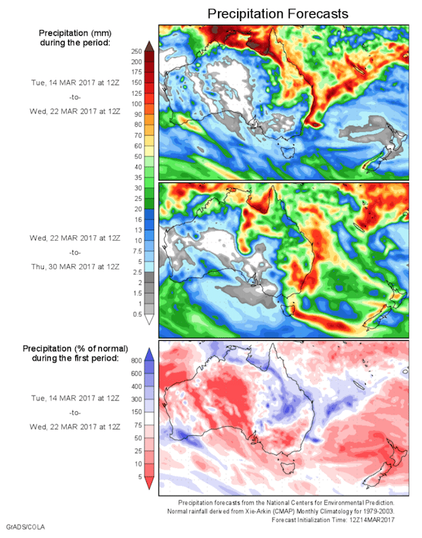
Today’s 14-day rainfall outlook – scroll to bottom of article
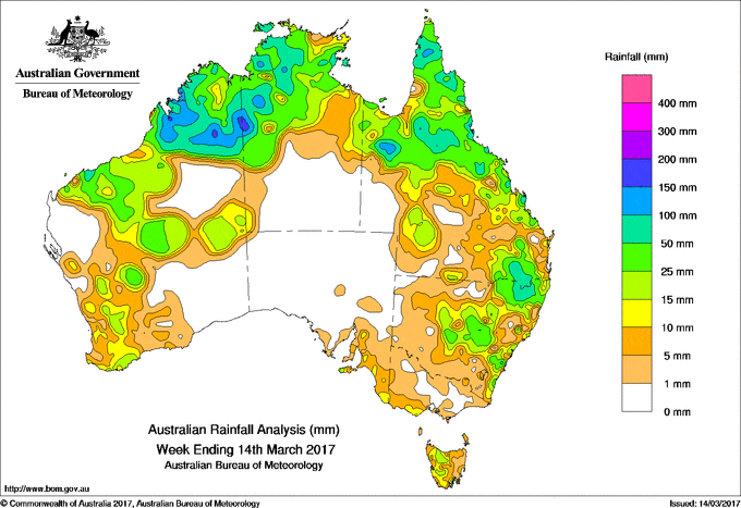
The biggest falls of rain across Australia in the past week were recorded in parts of the Kimberley, pockets of the west of the Northern Territory, and in locations in north-western Queensland.
Past seven days: At the beginning of the week, remnants of ex-tropical cyclone Blanche were located off the northwest coast of Australia and tracked slowly west-southwest, producing moderate to heavy falls in the Kimberley in Western Australia. Unsettled conditions persisted across the northwest, with a humid and unstable north to northeasterly flow generating showers and storms with moderate falls in northern and western parts of the Northern Territory.
In the east, a low- to middle-level trough extended over the northern interior of Queensland, enhancing shower and thunderstorms activity, with moderate falls recorded in parts the northern interior and western Queensland. As the trough shifted northwards, further moderate falls were recorded in the Capricornia, central and north tropical coasts, and adjacent inland districts. Showers contracted to the central and north tropical coasts and Cape York Peninsula by the middle of the week.
Showers and isolated thunderstorms continued in the north of Western Australia, the Top End, and the Gulf Country for the remainder of the week.
A surface trough was present near the west coast of Australia for most of the week, with a convective cloudband developing during the second half of the week ahead of a cold front passing over southwest Western Australia. Widespread showers and thunderstorms formed along a line from the Kimberley to the southwest.
Meanwhile, a complex low pressure system near Kangaroo Island moved eastwards, with an associated trough tracking across southeastern Australia and producing mostly light falls in southeastern South Australia, southwestern Victoria and western Tasmania.
At the end of the week thunderstorms and showers formed near a surface trough associated with this low complex, stretching from the southeast through western Queensland to the Northern Territory. Moderate falls were recorded in parts of the Darling Downs in southeast Queensland, northeastern, central, and pockets of southeastern New South Wales.
Rainfall totals in excess of 100 mm were recorded in parts of the Kimberley, pockets of the west of the Northern Territory, and in locations in northwestern Queensland. Isolated parts of the Kimberley recorded totals in excess of 150 mm, including the highest weekly total of 211 mm at Yeeda in Western Australia.
Rainfall totals between 50 mm and 100 mm were recorded across much of the Kimberley, locations along the Pilbara coast, and in much of the Victoria River district and western to central Top End in the Northern Territory. Similar totals were recorded in parts of the Cape York Peninsula and Gulf Country, pockets of east coast Queensland, and an area of northeastern New South Wales.
Rainfall totals between 10 mm and 50 mm were recorded in remaining parts of the Kimberley and Pilbara, in Western Australia’s Central Interior and Goldfields districts, and in parts of the South West Land Division; across the Top End and the northwest of the Northern Territory; much of northern and eastern Queensland as well as pockets in the southwest, southern interior and central west; and areas of central and eastern New South Wales. Totals of 5 mm to 15 mm were also recorded in southeastern South Australia, southwestern Victoria, and in western Tasmania, where some areas received in excess of 15 mm.
Little or no rainfall was recorded in much of the Gascoyne, northern Interior and southeast of Western Australia; the southern half of the Northern Territory; most of South Australia; most of Victoria away from the southwest; eastern Tasmania; western, inland northern and southern New South Wales; and southern and far western Queensland.
Highest weekly totals
New South Wales and Australian Capital Territory
102 mm Careys Peak (Barrington Tops)
90 mm Dubbo Airport AWS
86 mm Inverell (Raglan St)
Victoria
21 mm Lorne (Mount Cowley)
18 mm Benwerrin
17 mm Beech Forest
Queensland
178 mm Scherger RAAF
144 mm Upper Stone Exelby
141 mm Tully Sugar Mill
Western Australia
211 mm Yeeda
201 mm Willare Bridge
173 mm Nicholson
South Australia
21 mm Mount Lofty
20 mm Uraidla, Crafers West
Tasmania
28 mm Leslie Vale
26 mm Ouse Fire Station, Diddleum (Sowters Road)
Northern Territory
181 mm Katherine Country Club
155 mm Katherine – Bray Rd
123 mm Mount Felix
More weekly rainfall totals:
- NSW/ACT totals click here
- Vic totals click here
- Qld totals click here
- WA totals click here
- SA totals click here
- Tas totals click here
- NT totals click here
Source: BOM


HAVE YOUR SAY