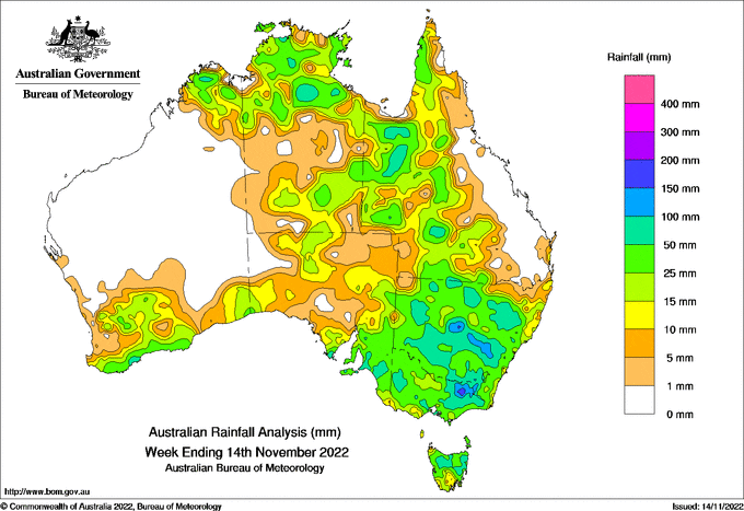
A HUMID northerly flow, combined with surface troughs, generated isolated showers and thunderstorms through central, eastern and south-eastern Australia on many days.
 At the end of the week, a surface trough associated with a low pressure system brought thunderstorms and widespread rainfall, with high daily totals in north-eastern Victoria, south-eastern New South Wales and areas on and west of the ranges in New South Wales.
Weekly rainfall totals above 50 mm were recorded in large parts of New South Wales, Victoria and western Queensland; within these there were areas that received more than 100 mm for the week. Weekly rainfall totals above 50 mm were also recorded in pockets of south-eastern South Australia, northern Tasmania and the far north of Western Australia and the Northern Territory.
The highest weekly total (at a Bureau gauge) of 204.0 mm was recorded at Mount Hotham in Victoria; the highest daily total this week was 118.0 mm at Forbes AP, New South Wales, in the 24 hours to 9am on 14 November.
Rainfall totals between 10 mm and 50 mm were recorded in much of New South Wales, Victoria, Tasmania and western Queensland, in parts of southern Western Australia, South Australia and the southern Northern Territory, and across the tropical north.
Rainfall this week caused flash flooding and renewed riverine flooding especially for large parts of New South Wales and Victoria.


HAVE YOUR SAY