Heavy rainfall in New South Wales coast eased as an East Coast Low moved well offshore as a trough and an onshore wind surge brought thunderstorms with moderate to locally heavy rain to eastern Queensland.
Weekly highlights
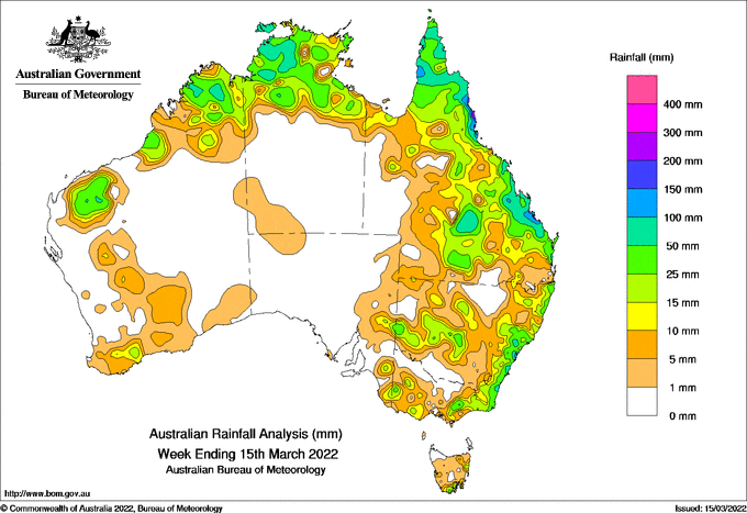
For the week to 15 March 2022, rainfall was recorded across northern Australia from the Pilbara and Kimberley in Western Australia through the Top End in the Northern Territory and on the Cape York Peninsula of Queensland. Heavy falls were recorded in some places along the eastern seaboard from Cairns to the New South Wales South Coast. Moderate falls were recorded over inland areas of Queensland and New South Wales, and Gippsland and alpine regions of Victoria. Mostly light falls were recorded in western and southern Victoria, eastern South Australia, Tasmania and parts of southern and central Western Australia.
At the start of the week, an East Coast Low brought heavy rain to coastal areas of New South Wales from the Mid North to the South Coast. This resulted in daily totals of up to 200 mm on Sydney’s Northern Beaches, with flash flooding in some suburbs and significant riverine flooding in the Hawkesbury-Nepean Valley. The East Coast Low subsequently moved away from the New South Wales coast, with an easing of the conditions in that region.
Later in the week, a trough over Queensland, combined with a south-easterly wind surge, generated thunderstorms along the central coast, with daily totals of 150 to 200 mm around Gladstone. Onshore winds moved northward, and the trough crossed northern Australia, generating more storms across northern Queensland, the Cape York Peninsula, the Top End of the Northern Territory, and the Kimberley in Western Australia. At the same time, the trough crossed the west of Western Australia bringing thunderstorms to the Pilbara, eastern Gascoyne and the South West Land Division. Rainfall was mostly light although daily totals of 25 to 50 mm were recorded in parts of the Pilbara.
The trough over inland eastern Australia developed more thunderstorms in central and western Queensland extending into central and western New South Wales. Isolated daily totals of 50 to 100 mm were reported in central Queensland south-east of Longreach.
At the end of the week, a burst of south-easterly winds brought moderate to locally heavy rainfall along the tropical north coast of Queensland, with isolated daily totals of up to 200 mm.
Weekly rainfall totals in excess of 100 mm were recorded in localised areas along the eastern seaboard around Cairns, Gladstone and the New South Wales Central Coast and Sydney Northern Beaches, and localised spots in the north-western Northern Territory. The highest weekly total was 383.0 mm at Mt Sophia on the coast south of Cairns in Queensland.
Weekly rainfall totals between 25 and 100 mm were recorded in parts of the Pilbara and Kimberley in Western Australia, the Top end of the Northern Territory, the Cape York Peninsula in Queensland, along much of the eastern seaboard from Queensland’s Tropical North Coast to Gippsland in Victoria, and in parts of central and western Queensland and New South Wales.
Weekly rainfall totals between 10 and 25 mm were recorded in isolated parts of south-west Western Australia, western Victoria and south-eastern South Australia. Parts of southern and central Western Australia, eastern South Australia, western and southern Victoria, and Tasmania generally received less than 10 mm of rainfall.


HAVE YOUR SAY