Rainfall for the week ending yesterday. Click on image to view in larger format.
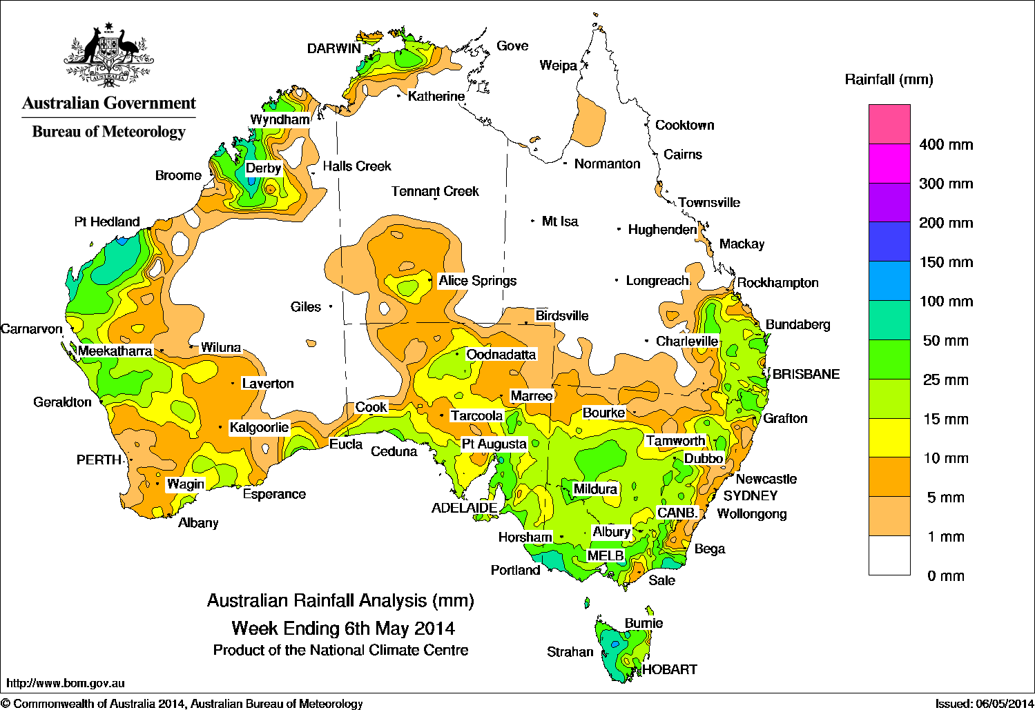
A weak low pressure system and surface trough over the inland Kimberley district of Western Australia generated storms with some moderate falls, while a cloudband with embedded showers and thunderstorms extended over South Australia, Victoria and Tasmania and western parts of New South Wales in association with a vigorous cold front moving through the Great Australian Bight and into the Tasman Sea at the beginning of the week.
Rainfall continued over the northern Kimberley coast and the northwest of the Northern Territory in association with the monsoon trough, while a surface trough along the Australian east coast triggered isolated thunderstorms in the southeastern corner of Queensland and parts of northern New South Wales.
A cold front moved across southern parts of Western Australia, strengthening as it approached the Great Australian Bight and moved into the Tasman Sea, where a low pressure system developed bringing moderate to heavy falls to inland New South Wales, western Victoria and southeastern South Australia as well as Tasmania.
At the week’s end, a low pressure system near the Gascoyne coast of Western Australia brought light to moderate falls to the northern South West Land Division and exposed west coast, but the system weakened as it moved inland.
Rainfall totals over 100 mm were recorded in elevated parts of the West Coast district of Tasmania and in small areas of the Pilbara East Coast and Kimberley districts of Western Australia, with the highest weekly total at Roebourne Aero in northwest Western Australia with 126 mm.
Falls between 25 mm and 100 mm were recorded in areas surrounding higher falls along most of western Tasmania, the South West and East Gippsland districts and central parts of Victoria, southeastern South Australia along the exposed coast and the northeastern Darwin-Daly area of the Northern Territory along with areas of inland New
South Wales, parts of southeastern Queensland, the North East Pastoral district of South Australia and areas of southwest Western Australia.
Falls between 10 mm and 25 mm were recorded in areas surrounding higher falls in southeastern Queensland, most of the New South Wales interior, remaining parts of Victoria and Tasmania, southern South Australia, along the Western Australian southern, west and northwest coast, and the northwest of the Northern Territory.
Large areas of inland and coastal Queensland, central Northern Territory and the interior of Western Australia extending into western parts of South Australia received little to no rainfall.
Highest weekly totals in each state:
| State | Highest | 2nd Highest | 3rd Highest |
|---|---|---|---|
| WA | Roebourne Aero (126 mm) (Fortesque) |
Roebourne (117 mm) (Fortesque) |
Ellendale (109 mm) (South Central) |
| NT | Channel Point (83 mm) (Darwin-Daly) |
Dum In Mirrie (75 mm) (Darwin-Daly) |
McMinns Lagoon (73 mm) (Darwin-Daly) |
| SA | Mount Gambier Aero (70 mm) (Lower Southeast) |
Melrose (67 mm) (Upper North) |
Belair (60 mm) (East Central) |
| Qld | Toolara (Kelly) (65 mm) (Moreton) |
Gympie (43 mm) (Moreton) |
Amberley (42 mm) (Moreton) |
| NSW / ACT | Hanging Rock (Andeva) (65 mm) (Northwest Slopes) |
Narrabri (63 mm) (Northwest Slopes) |
Nundle (Malonga) (92 mm) (Northwest Slopes) |
| Vic | Wyelangta (90 mm) (West Coast) |
Mount Baw Baw (86 mm) (West Gippsland) |
Dartmoor (81 mm) (West Coast) |
| Tas | Mount Read (114 mm) (West Coast) |
Lake Margaret (83 mm) (West Coast) |
West Pine (75 mm) (Northern) |
Source: Bureau of Meteorology


HAVE YOUR SAY