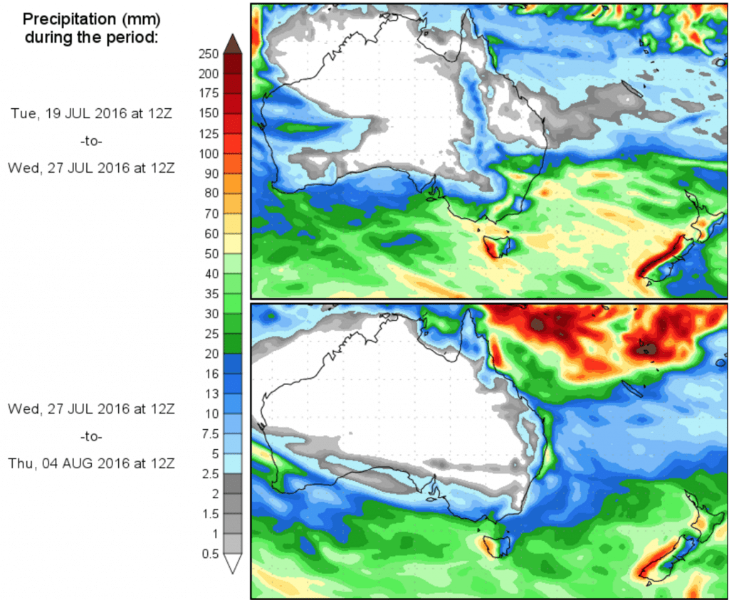
IS RAIN ON THE WAY? Scroll down to view today’s 14 day precipitation outlook
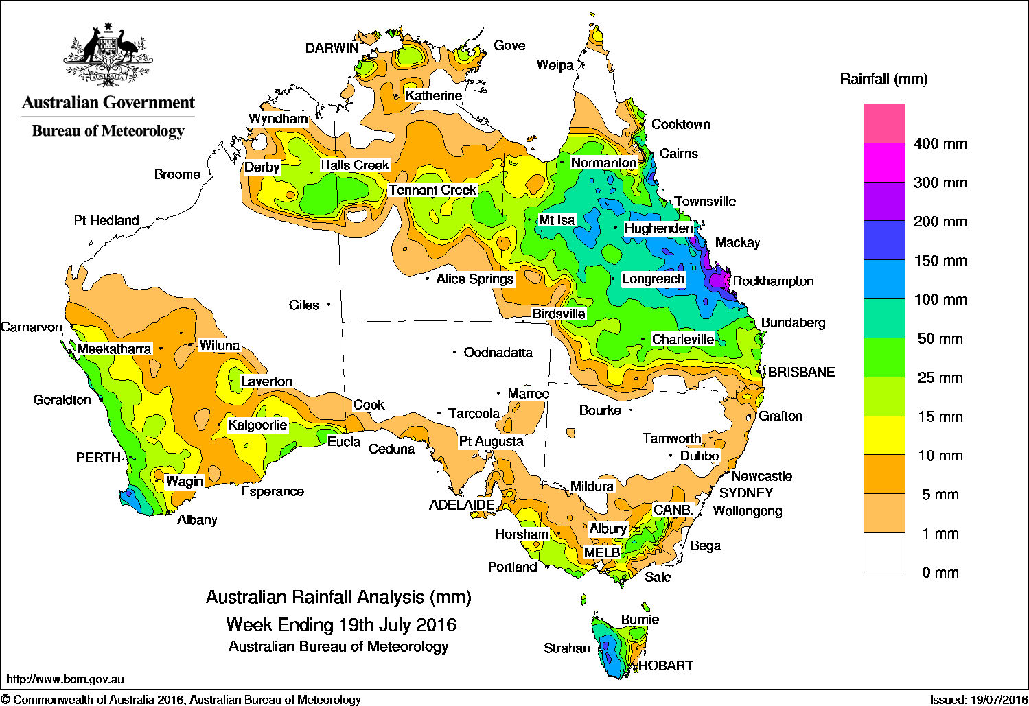
Central and northern Queensland received major totals in the last week, while heavy falls (50mm plus) were also recorded in southwest Western Australia, western Tasmania, and the Victorian Alps.
How the week panned out: At the start of the week, a vigorous westerly flow in the wake of strong cold front moved across the southeastern States and produced moderate rainfall totals in southern Victoria, southeastern South Australia and Tasmania. Elevated areas of the Victorian Alps and the Snowy Mountains in New South Wales also recorded moderate rainfall totals.
An upper-level trough produced a cloudband that streamed from the Kimberley in Western Australia, through the Northern Territory and Queensland. The cloudband generated moderate falls in parts of the Kimberley, the Barkly and Alice Springs area in the Territory, and northwest Queensland.
By the middle of the week, a low developed in the vicinity of the stationary upper-level trough off Queensland’s central coast. The system combined with a moist tropical air mass to further enhance the cloudband and generated widespread moderate to heavy rainfall through northern, central and southern tropical Queensland. Higher rainfall totals were recorded about the central and Capricornia coasts. In the west, a developing cloudband moved slowly from the northwest coast ahead of cold fronts and a weak low tracking across southwest Western Australia. The cloudband generated moderate to heavy rainfall in the western parts of the State. At the end of the week, the extensive cloudband tracked across central to southeastern Western Australia, then to the southeast of the continent. Light to moderate falls were recorded in the Goldfields and the Eucla coast in Western Australia, western Tasmania, northeast Victoria, and in the South West Slopes of New South Wales. A slow moving upper-level low over northwestern Queensland combined with an onshore flow to produce moderate to heavy falls to central Queensland, and along the north tropical Queensland coast.
100 mm and 200 mm: Southwest Western Australia, western Tasmania, and in northern and central Queensland.
50 and 100 mm: Southwest Western Australia, parts of the Victorian Alps, the western half of Tasmania, and large areas of central and northern Queensland.
10 mm and 50 mm: The Goldfields and Eucla districts, and parts of the Kimberley in Western Australia; in areas of the Top End and central parts of the Northern Territory; southeast of South Australia and in areas of southwest, southern and northeastern Victoria. Similar totals were recorded in northern and western Tasmania; southeastern New South Wales, and across most of Queensland except the Cape York Peninsula and the southwest.
Little to no rainfall: Remaining parts of Western Australia, areas in the south and the north of the Northern Territory, South Australia away from the southern coast, northern and eastern Victoria, southeastern Tasmania and the rest of New South Wales away from the Snowy Mountains.
Highest weekly totals in each State and Territory:
New South Wales and Australian Capital Territory
55 mm Thredbo Village
47 mm Perisher Valley AWS
45 mm Ginninderra (Charnwood (Act))
Victoria
73 mm Falls Creek (Rocky Valley)
68 mm Haines Junction (Mount Sabine)
50 mm Apollo Bay
Queensland
485 mm Byfield Childs Road
443 mm Pacific Heights
378 mm Yeppoon The Esplanade
Western Australia
232 mm Jarrahwood
189 mm Yoongarillup Tbrg
188 mm Happy Valley
South Australia
25 mm Goolwa Council Depot
20 mm Mount Gambier Aero
19 mm Nangwarry Forestry Sa Depot
Tasmania
202 mm Lake Margaret Power Station, Mount Read*
163 mm Warra
Northern Territory
52 mm Geriatric Park, Wave Hill
42 mm Black Point
* the gauge at Mount Read was affected by snow; the true total is not known but is probably higher
More weekly rainfall totals:
- NSW/ACT totals click here
- Vic totals click here
- Qld totals click here
- WA totals click here
- SA totals click here
- Tas totals click here
- NT totals click here
Source: BOM
Click on image to view in larger format.


HAVE YOUR SAY