AFTER several dry years across northern Australia, wet season 2020–21 saw a welcome return to above-average rainfall. Overall it was northern Australia’s wettest and coolest October to April wet season since 2016–17.
La Niña brought rain
The wet season got off to a flying start, with a wet October as La Niña became established in the tropical Pacific Ocean. The northern rainfall onset is the first 50 mm of rain accumulated after 1 September. It occurred many weeks earlier than normal in central and north-western parts of the Northern Territory.
However, November was dry across the north. La Niña temporarily weakened and the Madden–Julian Oscillation stalled near Africa. This meant weather patterns over Australia suppressed rather than encouraged rainfall. It was also the warmest November on record, with the overall mean temperature 2.37 °C above the long-term (1961–1990) average.
Wet conditions returned as monsoonal and tropical low activity contributed to the second-wettest December on record for northern Australia, behind 2000. Typical of a La Niña year, the monsoon at Darwin began earlier than usual. The official monsoon onset date of 19 December 2020 was about 10 days earlier than the long-term average. It was over a month earlier than in the previous 3 wet seasons.
Above-average rainfall continued into 2021, although not to the same extent as December. Northern Western Australia was affected by several tropical lows. One brought heavy rains in the Kimberley and east Pilbara areas in January. Another resulted in parts of western Gascoyne having their wettest February on record, along with extensive flooding. During March, there was moderate to heavy rainfall across the Kimberley extending into western and southern Northern Territory. There was moderate flooding on the Fitzroy and Ord Rivers.
In response, water levels in Lake Argyle, Australia’s largest water supply storage, reached 82.1% of capacity by the end of March. In November 2020, following 3 below-average wet seasons, water levels there had fallen to 25%, their lowest in 30 years.
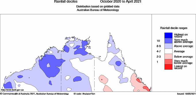
Map: Northern Australia rainfall for the 2020–21 wet season, compared with all years since 1900
Queensland rainfall in 2021 was largely restricted to northern areas and the Cape York Peninsula. Weather patterns were less favourable for rain further south. A significant exception was from 17 to 26 March, when tropical air interacted with a slow moving coastal low. This produced heavy rain and some flooding across central and southern Queensland.
Early March saw moderate rain along the Cairns coast and in northern Cape York Peninsula from tropical cyclone Niran. On 17 March, a deep surface trough off the Capricornia coast resulted in an isolated report of 550 mm at Byfield, north of Yeppoon. This was the highest daily total of the wet season.
Far north Queensland had another major rain event when the coastal area around Cairns received between 600 and 1100 mm between 19 and 26 April. Mt Sophia, south of Cairns, had the highest recorded total of 1104 mm. Such significant rainfall hasn’t been seen during April in the Cairns area in over 100 years – since 1911.
Fewer tropical cyclones than usual
There were 8 tropical cyclones this wet season. This is below the long-term average count of 11 and the average of 9 since 2000. However, there were around a dozen tropical lows. Several brought significant rain to northern Australia.
Of the tropical cyclones, 4 occurred off Western Australia and 4 off Queensland. For the first time since 2015–16 there were no tropical cyclones within the Northern Territory.
Two cyclones made coastal crossings. Tropical cyclone Imogen made landfall on the south coast of the Gulf of Carpentaria in January as a category 1 system. Severe tropical cyclone Seroja had a significant impact on Western Australia’s central west area. It made landfall in early April as a category 3 system. Winds of up to 170 km/h caused considerable damage to Kalbarri and nearby localities. Seroja is likely the strongest cyclone to have affected the area since satellite observations began in the 1970s.
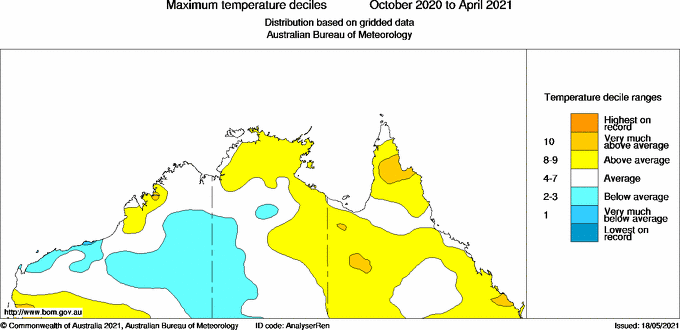
Coolest temperatures for 4 years
La Niña also contributed to relatively cool conditions across northern Australia during the wet season after several very warm years. The mean maximum and minimum temperatures were 0.45 °C and 0.74 °C above the long-term average respectively, the coolest since 2016–17.
Map: Northern Australia mean maximum temperatures for the 2020–21 wet season, compared with all years since 1910
More information
Source: Bureau of Meteorology. More information on the climate across the 2020–21 wet season is available at our Climate Summaries archive.


HAVE YOUR SAY