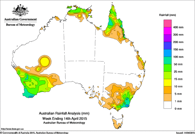
It has been a dry week for large parts of Australia with the exception of Western Australia’s South West, the Top End of the Northern Territory, Cape York Peninsular and Australia’s south eastern corner.
At the start of the week, a complex low pressure system located in the Tasman Sea produced moderate rainfall totals across southeastern New South Wales and eastern Victoria. Areas of low pressure across the tropics produced showers and storms, with moderate rainfall totals recorded across the Top End of the Northern Territory and through areas of the northern Cape York Peninsula in Queensland.
A low pressure system and associated surface trough near the west coast of southwest Western Australia generated a cloudband. The low deepened along the surface trough as it moved over the southwest corner of Western Australia by mid-week. The system produced moderate to heavy rainfall across the southwest and southern coast of Western Australia before moving into the Great Australian Bight in the second half of the week.
A persistent, moist easterly flow along the east coast of Queensland generated showers and isolated thunderstorms, with moderate falls recorded in Queensland’s north tropical coast, parts of the Cape York Peninsula and small areas of the central east coast.
Rainfall totals in excess of 50 mm were recorded in the southwest tip of Western Australia, parts of the Cape York Peninsula in Queensland, and in the area spanning far southeastern New South Wales and far eastern Victoria. Isolated totals in excess of 100 mm were recorded in small areas of the north tropical Queensland coast, southwest Western Australia, East Gippsland in Victoria and the southeast corner of New South Wales. The highest weekly total of 166 mm was recorded at Macknade Sugar Mill, north of Townsville in Queensland.
Rainfall totals between 10 mm and 50 mm were recorded between the South West Land Division and South Coast District in Western Australia, across central southern and eastern Victoria, southeastern New South Wales, the northern Top End and much of the Cape York Peninsula.
Most of western and northern New South Wales, Queensland except for the Peninsula, the Northern Territory away from the Top End, the northern half and east of Western Australia, western Victoria, Tasmania and South Australia recorded little or no rainfall for the week.
Table of highest weekly totals
| State | Highest | 2nd Highest | 3rd Highest |
|---|---|---|---|
| WA | Porongurups (130 mm)  (South Coast) |
Tamaru (127 mm) (South Coast) |
Mount Barker (120 mm) (South Coast) |
| NT | Gunn Point (92 mm) (Darwin-Daly) |
Charles Point (55 mm) (Darwin-Daly) |
Milingimbi Airport (44 mm) (Arnhem) |
| SA | Flinders Chase (7 mm) (Kangaroo Island) |
Myponga (7 mm) (Mount Lofty Ranges) |
American River (6 mm) (Kangaroo Island) |
| Qld | Macknade Sugar Mill (166 mm) (Herbert) |
Mt Sophia (149 mm) (Barron) |
Halifax (148 mm) (Herbert) |
| NSW/ACT | Jerangle (Lyons Creek) (142 mm) (Goulburn-Monaro) |
Snowball (99 mm) (South Coast) |
Parkers Gap (99 mm) (Goulburn-Monaro) |
| Vic | Bonang (145 mm) (East Gippsland) |
Buchan (134 mm) (East Gippsland) |
Combienbar (123 mm) (East Gippsland) |
| Tas | Catamaran (13 mm) (Southeast) |
Mount Wellington (12 mm) (Southeast) |
Fern Tree (Grays Road) (11 mm) (Southeast) |
Source: BOM


HAVE YOUR SAY