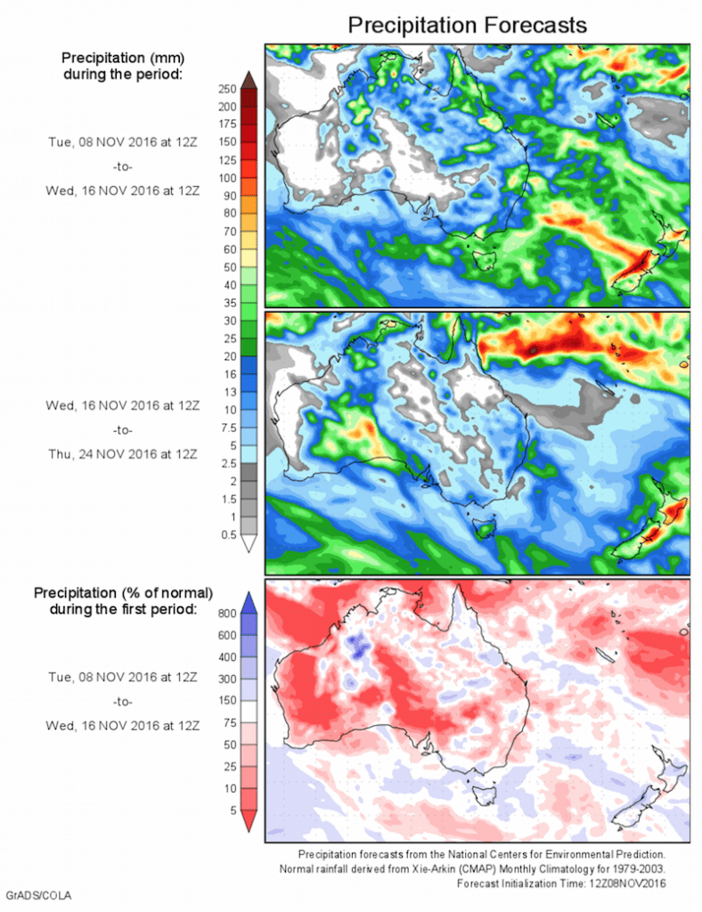
Today’s 14-day rainfall outlook – scroll to bottom of article
The biggest falls of the past week were recorded in central and western Tasmania, parts of central Queensland, in the west and north of the Northern Territory.
Past seven days: Rainfall was recorded in central and northern parts of Western Australia; in the west, eastern parts and the Top End of the Northern Territory; northern and eastern Queensland; a small area on the northern New South Wales coast; central southern Victoria and western Tasmania.
At the beginning of the week, a broad trough of low pressure over northern Australia generated showers and thunderstorms with moderate rainfall across the Kimberley region and through the Northern Territory and western Queensland. In the south, a cool southerly airstream associated with the passage of a cold front produced widespread light falls over southern Victoria, and moderate falls in western Tasmania. A moist easterly onshore flow produced moderate falls in parts of southeastern Queensland and northeastern New South Wales.
During the middle of the week, a moist unstable air mass developed along the east coast, leading to the formation of showers and storms, with moderate falls reported along the Queensland central coast and the northern interior. A trough over Western Australia generated isolated thunderstorms in the central interior district. A cool southwesterly airstream brought moderate falls to western Tasmania.
At the end of the week, isolated thunderstorms formed along a broad low pressure trough extending from the west coast of Western Australia, up through the Top End and into northwest Queensland. Moderate falls were recorded about the Kimberley coast, the northwestern Top End and the Gulf Country.
50 mm and 100 mm: Central and western Tasmania, parts of central Queensland, in the west and north of the Northern Territory. Rainfall totals in excess of 100 mm were recorded along the west coast of Tasmania. The highest weekly total was 244 mm at Mount Read in Tasmania.
10 mm and 50 mm: The central and northern interior, and Kimberley district in Western Australia, in the west, north and east of the Northern Territory, in the northwest and along parts of the east coast of Queensland. Similar totals were recorded along a small part of the northeastern New South Wales coast, an area of southern central Victoria, and the western half of Tasmania.
Little to no rainfall: South Australia, remaining parts of Western Australia, and in central, southern and parts of the northeast of the Northern Territory. Little or no rainfall was also recorded in northern, western and southern Queensland; New South Wales; northern, eastern and western Victoria; and eastern Tasmania.
Highest weekly totals list and map
New South Wales and Australian Capital Territory
38 mm Coffs Harbour Airport
21 mm Kempsey Airport AWS
Victoria
30 mm Moe South
27 mm Mount Best (Upper Toora)
25 mm Madalya
Queensland
95 mm Booroondarra
73 mm Mackay Aero
71 mm Ooralea Racecourse (Mackay Tur
Western Australia
51 mm Marion Downs
47 mm Wiluna
41 mm Kalumburu
South Australia
7 mm Kingscote
5 mm PenneshawRobePenola Post Office
Tasmania
244 mm Mount Read
179 mm Lake Margaret Power Station
157 mm Queenstown (South Queenstown)
Northern Territory
95 mm Darwin River Dam, Noonamah Airstrip
88 mm Pirlangimpi Airport
More weekly rainfall totals:
- NSW/ACT totals click here
- Vic totals click here
- Qld totals click here
- WA totals click here
- SA totals click here
- Tas totals click here
- NT totals click here
Source: BOM


HAVE YOUR SAY