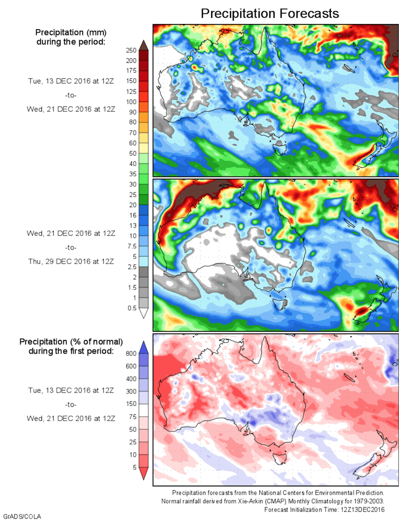
Today’s 14-day rainfall outlook – scroll to bottom of article
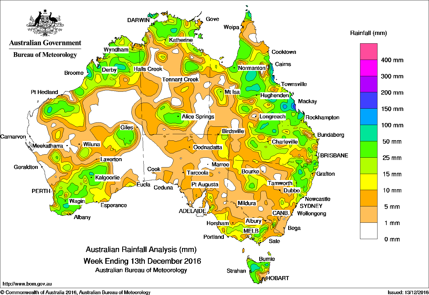
Pockets of the Kimberley, Pilbara and South West Land Division in Western Australia; parts of the Top End in the Northern Territory; areas of northern and central Queensland, northeastern New South Wales and northern Tasmania received the biggest falls in the past week.
Past seven days: Rainfall was recorded in the central interior, northern, and southern parts of Western Australia; the south and north of the Northern Territory; northern, central and southern areas of Queensland; northeastern and western New South Wales; central and western Victoria; western and northern Tasmania, and in southeastern and northeastern South Australia.
In the first part of the week, a broad trough of low pressure extended from a tropical low off the northwest Australian mainland, through northern and central Australia, to the east coast of the continent. Cloudbands with embedded thunderstorms and showers formed over northern and central Western Australia, southern parts of the Northern Territory, northern parts of South Australia, southern Queensland and northern New South Wales.
A cold front and associated low pressure system deepened as it tracked from South Australia to the southeast of the country, generating moderate falls in parts of southeastern South Australia, western Victoria and northern Tasmania. Light to moderate rainfall was recorded over most of Tasmania apart from the southeast, and much of Victoria.
During the second part of the week, a coastal trough and a moist onshore flow generated rain and thunderstorm activity over the Capricornia, central, and north tropical coasts of Queensland, with some locally heavy falls recorded. Moderate to heavy falls spread west through the Queensland central interior, Gulf Country and Cape York Peninsula as the surface and upper level trough intensified. A surface trough across northern Western Australia and the Top End triggered thunderstorms with moderate to locally heavy falls recorded in parts of the Kimberley and Pilbara districts, and northern parts of the Northern Territory.
A deep trough located inland from the west coast of Western Australia, along with an upper level disturbance, produced a cloudband with embedded thunderstorms. Moderate to locally heavy falls were recorded in parts of the Gascoyne, the South West Land Division and the southern Goldfields in Western Australia.
50mm-100mm: Pockets of the Kimberley, Pilbara and South West Land Division in Western Australia; parts of the Top End in the Northern Territory; areas of northern and central Queensland, and northeastern New South Wales, and in parts of northern Tasmania. Isolated falls in excess of 100 mm were recorded in Queensland’s north tropical and central coasts, and parts of the State’s central and northern interior. The highest weekly total was 293 mm at Orkabie West Hill in Queensland.
10mm-50mm: Large areas of the South West Land Division, Gascoyne, southern Goldfields and Southern Interior districts of Western Australia; in central and northern parts of the Northern Territory; northern, central and southern Queensland; northeastern and western parts of New South Wales; central and western Victoria; western and northern Tasmania; and in southeastern and northeastern parts of South Australia.
Little or no rainfall: Along much of the west coast, and eastern parts of Western Australia; western, central and eastern areas of the Northern Territory; the pastoral districts and western South Australia; northwest and eastern Victoria; western, central and southern parts of New South Wales; and in western Queensland.
Highest weekly totals list
New South Wales and Australian Capital Territory
97 mm Bukkulla (RFS)
70 mm Lillian Rock (Williams Road)
66 mm Mount George (Manning River)
Victoria
51 mm Woods Point
44 mm Bullarto South, Mount Hotham, Mount Baw Baw
Queensland
293 mm Orkabie West Hill
234 mm Gairloch
229 mm Coconut Island
Western Australia
87 mm Broome Airport
75 mm Lansdowne
72 mm Chamingup
South Australia
29 mm Birdwood (Mcvittie’s Hill)
28 mm Aldgate
27 mm Cromer Road
Tasmania
105 mm Mount Read
102 mm Mount Victoria (Una Plain)
66 mm Mount Barrow (South Barrow)
Northern Territory
112 mm Stokes Hill
103 mm Pirlangimpi Airport
98 mm Fort Hill Wharf
More weekly rainfall totals:
- NSW/ACT totals click here
- Vic totals click here
- Qld totals click here
- WA totals click here
- SA totals click here
- Tas totals click here
- NT totals click here
Source: BOM


HAVE YOUR SAY