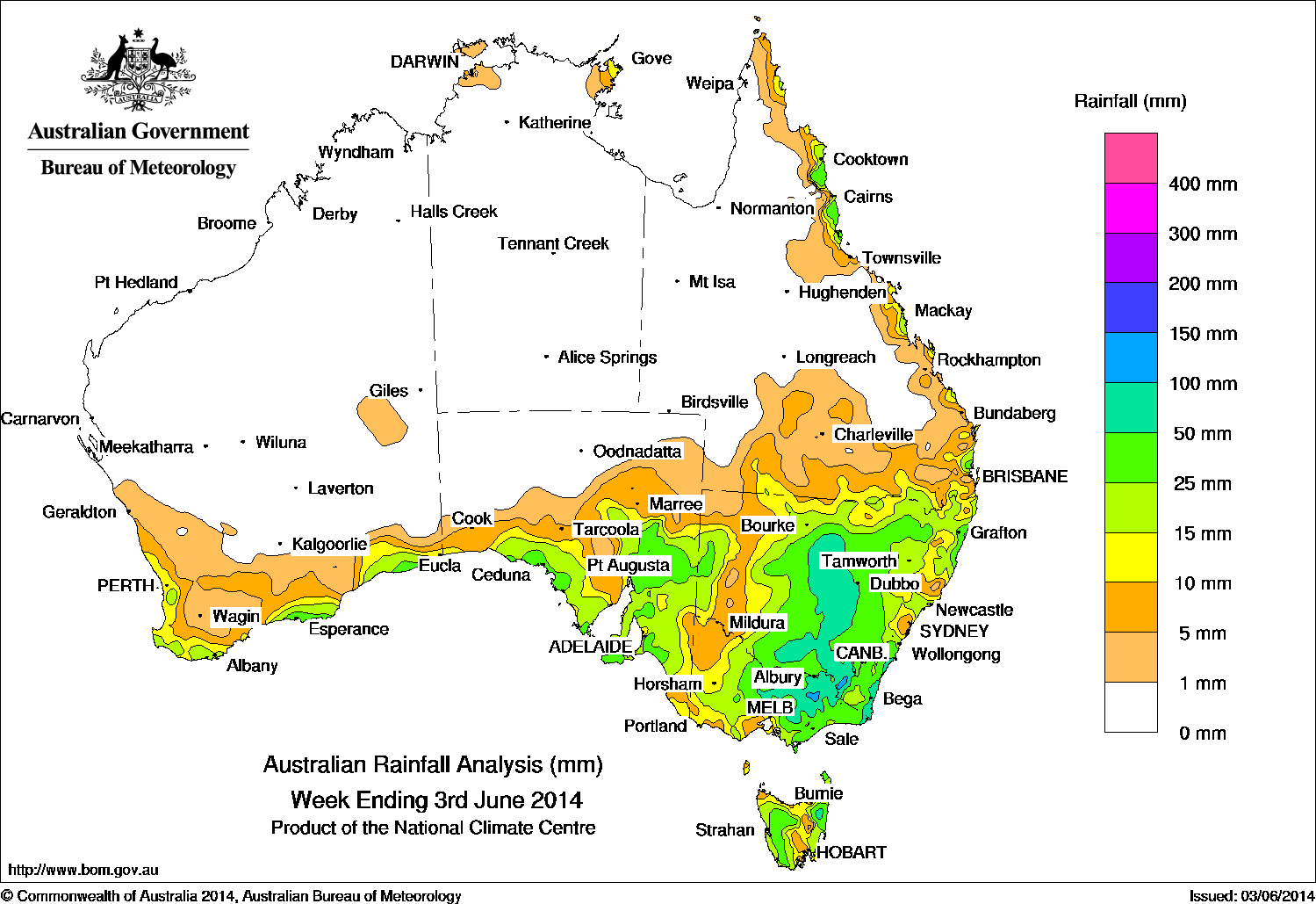
Rainfall recorded across Australia for the seven days until yesterday. Click on map to view in larger format.
Large parts of inland New South Wales and Victoria and areas of South Australia received falls of 25-50mm of rain in the past week.
At the start of the week, a cold front over southern Australia brought areas of rain and isolated thunderstorms to southern New South Wales, Victoria and Tasmania, and showers and thunderstorms over southern South Australia. A second front associated with a cut-off low also tracked across the Great Australian Bight, resulting in light but widespread rain along the southern coast of Western Australian and slightly heavier falls in coastal southwestern South Australia.
By mid-week a surface trough extended from the cut-off low pressure system and into South Australia. A band of rain-bearing cloud with embedded thunderstorms associated with the surface trough moved through southeastern Australia. Meanwhile, moist onshore winds brought low cloud and light to moderate rain along the east coast.
At the end of the week, the surface trough moved east and a broad cloudband extended from the southern interior of Queensland through eastern New South Wales to a low pressure system centred over western Victoria, with areas of moderate falls recorded on the east of the mainland and Tasmania.
The highest weekly total of 145 mm was recorded at Mount Hotham in the Victorian Alps.
Rainfall totals between 50 mm and 150 mm were recorded in the Snowy Mountains and Southwest Slopes of New South Wales, elevated parts of northeastern Victoria and northeast of Tasmania.
Rainfall totals between 25 mm and 50 mm were recorded surrounding areas of higher falls in eastern Victoria, much of inland New South Wales, and also in areas along Australia’s southern coastal, South Australia’s Flinders District, western Tasmania and on the north tropical coast of Queensland.
Rainfall totals between 10 mm and 25 mm were recorded surrounding higher falls and from coastal southwest Western Australia and along the coast to western Victoria. Similar totals fell in northern coastal New South Wales, along the Queensland–New South Wales border and exposed parts of the Queensland coast.
The Northern Territory, Queensland away from the east coast, northern South Australia, and most of Western Australia away from the southern coastline recorded little or no rainfall during the week.
Highest weekly totals for each State:
| State | Highest | 2nd Highest | 3rd Highest |
|---|---|---|---|
| WA | Esperance (41 mm) (South Coast) |
Merivale Farm (37 mm) (South Coast) |
Jarrahdale (34 mm) (Central Coast) |
| NT | Alcan Minesite (16 mm) (Arnhem) |
Gove Airport (14 mm) (Arnhem) |
Yirrkala Tropical Gardens (13 mm) (Arnhem) |
| SA | Meadows (59 mm) (East Central) |
Wilpena (Oraparinna) (50 mm) (Upper North) |
Uraidla (49 mm) (East Central) |
| Qld | Tully Sugar Mill (58 mm) (Herbert) |
Tree House Creek (53 mm) (Barron) |
Daradgee (50 mm) (Herbert) |
| NSW/ACT | Perisher Valley (123 mm) (Snowy Mountains) |
Thredbo (96 mm) (Snowy Mountains) |
Cabramurra (92 mm) (Southwest Slopes) |
| Vic | Mount Hotham (145 mm) (Upper Northeast) |
Gabo Island Lighthouse (131 mm) (East Gippsland) |
Mount Baw Baw (107 mm) (West Gippsland) |
| Tas | St Marys (88 mm) (Northern) |
Pyengana (68 mm) (East Coast) |
Gray (68 mm) (East Coast) |
Source: BOM


HAVE YOUR SAY