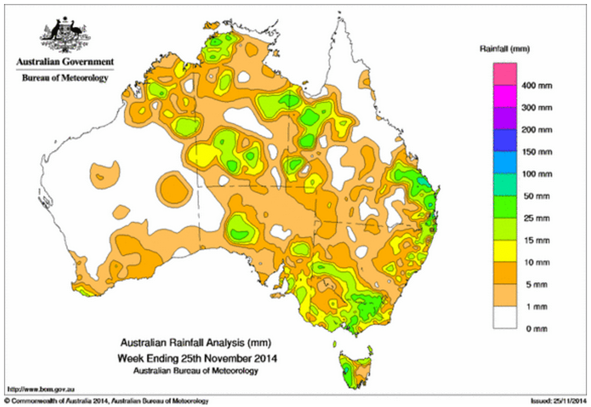
Rainfall recorded across Australia in the seven days until yesterday.
Rainfall was recorded in all States and Territories in the past week.
At the beginning of the week, a surface trough extended from northwest Australia through inland Queensland into northeastern New South Wales, triggering thunderstorms and showers. Moderate to heavy falls were recorded along the coast between Rockhampton, Queensland, and Tweed Heads, New South Wales. Areas of low pressure also extended from inland Western Australia towards a low pressure system in the Southern Ocean. Generally light rainfall was recorded in areas along the southern coast and Tasmania early during the week as the trough system moved into eastern Australia.
Later in the week, a cloudband extended along a trough from the Kimberley district in Western Australia, south of the Gulf of Carpentaria and into northeastern New South Wales. Isolated showers and thunderstorms were recorded along the line of the cloudband.
From the 22nd, a trough formed across southern Australia, extending from the Pilbara coast to the southeast, and bringing light falls to much of central Australia and the southeast.
A cold front brought light falls to the southwest of Western Australia towards the end of the week before intensifying and moving into the southeast. A trough which lay around the western and northern coast extended through eastern Australia as a pre-frontal trough. Moderate to heavy rainfall was recorded in western Tasmania, much of Victoria and southern New South Wales, with lighter falls in eastern New South Wales. Thunderstorms along the trough brought moderate totals to parts of western Queensland, the Top End and northern Western Australia.
Rainfall totals in excess of 25 mm were recorded in western Tasmania, along the southeast coast of Queensland, in the South West Slopes district of New South Wales, parts of eastern Victoria, and isolated areas in pastoral South Australia and between western Queensland and the Kimberley. Individual higher totals were common, with the highest weekly total 129 mm at Bangalow in New South Wales.
Rainfall totals between 10 mm and 15 mm were recorded in far southwest Western Australia, areas of the Kimberley, Northern Territory, western Queensland, southeastern South Australia, northeast and southern New South Wales, central and southwestern Victoria, northern Tasmania and surrounding higher falls in other parts of the mainland southeast.
Remaining parts of Western Australia, areas of the Northern Territory, northeastern and inland southern Queensland, northwest New South Wales, northwest Victoria, and across the north and west of South Australia recorded little or no rainfall for the week.
Highest weekly rainfall totals in each State:
| State | Highest | 2nd Highest | 3rd Highest |
|---|---|---|---|
| WA | Kununurra (80 mm) (East Kimberley) |
Mornington (49 mm) (East Kimberley) |
Mount Barnett (39 mm) (West Kimberley) |
| NT | Majestic Orchids (78 mm) (Darwin-Daly) |
Keep River Rangers (48 mm) (Darwin-Daly) |
Batchelor Airport (44 mm) (Darwin-Daly) |
| SA | Myponga (34 mm) (East Central) |
Rosedale (30 mm) (East Central) |
Freeling (28 mm) (East Central) |
| Qld | Childers South (94 mm) (Port Curtis) |
Boondall (87 mm) (Moreton) |
Mount Wallaby (77 mm) (Port Curtis) |
| NSW/ACT | Bangalow (Fowlers Lane) (129 mm) (Upper North Coast) |
Boat Harbour (Rous River) (59 mm) (Upper North Coast) |
Rosebank (58 mm) (Upper North Coast) |
| Vic | Hurdle Creek (51 mm) (Lower Northeast) |
Tangambalanga (50 mm) (Lower Northeast) |
Rosewhite (44 mm) (Lower Northeast) |
| Tas | Mount Read (79 mm) (West Coast) |
Queenstown (52 mm) (West Coast) |
Lake Margaret (46 mm) (West Coast) |
Source: BOM


HAVE YOUR SAY