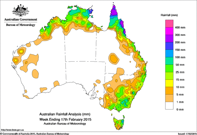
Rainfall received across Australia for the seven days until yesterday.
Across the past week, rainfall was recorded in the North Kimberley of Western Australia, across the Top End of the Northern Territory, northern and eastern Queensland, southern and eastern New South Wales, central and eastern Victoria, and northern Tasmania.
Rainfall totals in excess of 300mm were recorded along the north tropical coast of Queensland and northern Cape York Peninsula, with higher falls in isolated parts of northern Queensland.
Rainfall totals over 100 mm were recorded in far north Queensland along the north tropical coast, northern Cape York Peninsula, eastern Arnhem Land in the Northern Territory, in an isolated area of the Central Tablelands in New South Wales, and in a small area in northeastern Tasmania.
Falls of between 50 mm and 100 mm were recorded along the coast of the West Kimberley district in Western Australia, parts of the Top End in the Northern Territory, much of Cape York Peninsula and the north tropical coast of Queensland, a small area of southeast Queensland and northeastern New South Wales, the Snowy Mountains in New South Wales, and northeastern Tasmania.
Totals between 10 mm and 50 mm were recorded in isolated areas of the Gascoyne and Pilbara districts and surrounding higher falls in the Kimberley district extending into the Top End of the Northern Territory, and on the Cape York Peninsula and the north tropical coast, along the east coast of Queensland, eastern and southern New South Wales as well as parts of Western Slopes, including parts on western New South Wales, much of eastern and central Victoria, and the northern half of Tasmania.
Much of central southern and eastern Western Australia, southern half of the Northern Territory, most of South Australia, northwestern New South Wales, and most of inland and western Queensland away from the coast and Cape York Peninsula recorded little or no rainfall for the week.
At the beginning of the week, a surface and middle level trough produced tropical convection over northern Australia, with light to moderate rainfall totals recorded over the Kimberley in Western Australia, the Top End of the Northern Territory, Cape York Peninsula and parts of the north tropical coast of Queensland. A moist, onshore flow brought light rainfall to parts of the southeastern Queensland and northeastern New South Wales, with higher falls received around the coastal areas.
Moderate rainfall totals were recorded in northeastern Victoria and southeastern New South Wales in the wake of a pre-frontal trough that crossed Bass Strait. Light rainfall continued through parts of southern and eastern New South Wales as the weakening trough transitioned off the east coast.
A weak low pressure system near Cape York Peninsula associated with a monsoon trough triggered thunderstorms across the tropical north, resulting in moderate to heavy rainfall totals across parts of far northern Queensland and the north tropical coast. Moderate rainfall was also recorded across areas of Arnhem Land in the Northern Territory and in Western Australia’s Kimberley district.
During the second half of the week, a low pressure trough extending from South Australia into southern New South Wales produced moderate rainfall totals over a large area of southern, central and eastern Victoria, northern Tasmania, and parts southeastern New South Wales. The strengthening monsoon trough extended from the far north of the Gulf of Carpentaria into the northwestern Coral Sea, with a low pressure system deepening on the trough over the north of the Gulf of Carpentaria. Moderate to heavy rainfall was recorded on the Cape York Peninsula and north tropical coast of Queensland, and across the Top End of the Northern Territory. At the end of the week, tropical cyclone Lam formed early on the morning of 17 February in the Gulf of Carpentaria, bringing heavy rainfall to parts of Arnhem Land in the Northern Territory and Cape York Peninsula in Queensland.
Table of highest weekly totals
| State | Highest | 2nd Highest | 3rd Highest |
|---|---|---|---|
| WA | Mount Hart Station (62 mm) (West Kimberley) |
Pyramid Station (38 mm) (De Grey) |
Lake Argyle Resort (36 mm) (East Kimberley) |
| NT | Alcan Minesite (259 mm) (Arnhem) |
Gove Airport (168 mm) (Arnhem) |
Groote Eylandt Airport (100 mm) (Arnhem) |
| SA | Mintaro (6 mm) (Lower North) |
Appila (4 mm) (Upper North) |
Riverton (3 mm) (East Central) |
| Qld | Lockhart River Airport (573 mm) (South Peninsula) |
Mt Sophia (368 mm) (Barron North Coast) |
Moreton Telegraph Station (324 mm) (North Peninsula) |
| NSW/ACT | Blackheath (Wombat Street (101 mm) (Central Tablelands) |
Wentworth Falls Country (97 mm) (Central Tablelands) |
Blackheath (Lawrence St) (90 mm) (Central Tablelands) |
| Vic | Mount Buller (86 mm) (Upper Northeast) |
Howitt Plains (High Ridge (83 mm) (Upper Northeast) |
Rosewhite (77 mm) (Lower Northeast) |
| Tas | Mount Victoria (Una Plain) (181 mm) (Northern) |
Pyengana (Forest Lodge) (169 mm) (East Coast) |
Mathinna (South Esk River) (122 mm) (East Coast) |
Source:BOM


HAVE YOUR SAY