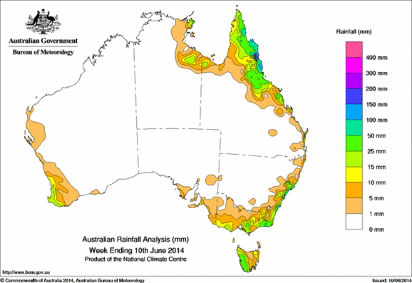
Rainfall recorded across Australia for the seven days to 9am yesterday. Click on map to view in larger format.
The tropical north, southeastern Australia and southwest Western Australia received the heaviest rain for the week ending June 10.
A series of cold fronts crossing the Southern Ocean during the first half of the week brought rain over parts of southeastern Australia and Tasmania, and along the New South Wales coast.
Thunderstorm activity throughout parts of the Northern Territory and across eastern districts of Queensland brought some moderate falls early in the week.
At the end of the week, scattered thunderstorms associated with a trough of low pressure formed along the east coast of Victoria and New South Wales, generating some light to moderate falls.
The highest weekly total of 172 mm was recorded at Norah Head in the Hunter region of New South Wales. Rainfall totals over 100 mm were recorded on Queensland’s northern tropical coast and locations in the Hunter region in New South Wales. Areas of falls in excess of 50 mm were also recorded in the far northern Cape York Peninsula, the central coast of New South Wales, and in East Gippsland in Victoria.
Rainfall totals between 25 mm and 50 mm were recorded in areas surrounding higher falls and far eastern and central Victoria, central and southern coastal New South Wales, western Tasmania, and from Queensland’s central coast to the east of Cape York Peninsula.
Rainfall totals of more than 10 mm were also recorded in southwestern and eastern Victoria, parts of the alpine region, southeast coastal New South Wales, southwest Western Australia, and in areas around the Gulf of Carpentaria and parts of the exposed Queensland coast.
Most of Western Australia, South Australia, the Northern Territory and the inland areas of eastern states recorded little or no rainfall.
Highest weekly totals for each State:
| State | Highest | 2nd Highest | 3rd Highest |
|---|---|---|---|
| WA | Jarrahwood (32 mm) (South Coast) |
Witchcliffe (32 mm) (South Coast) |
Windy Harbour (32 mm) (South Coast) |
| NT | Gove Airport (30 mm) (Arnhem) |
Nhulunbuy (26 mm) (Arnhem) |
Yirrkala Tropical Gardens (20 mm) (Arnhem) |
| SA | Parawa (Second Valley) (18 mm) (East Central) |
Parawa (Sharon) (17 mm) (East Central) |
Coulta (15 mm) (Western Agricultural) |
| Qld | South Johnstone (134 mm) (Herbert) |
Innisfail (132 mm) (Herbert) |
Daradgee (121 mm) (Herbert) |
| NSW/ACT | Norah Head (172 mm) (Hunter) |
Careys Peak (Barrington Tops) (146 mm) (Hunter) |
Nelson Bay (Nelson Head) (144 mm) (Hunter) |
| Vic | Cabbage Tree Creek (52 mm) (East Gippsland) |
Club Terrace (48 mm) (East Gippsland) |
Mount Baw Baw (45 mm) (West Gippsland) |
| Tas | Queenstown (South Queenstown) (42 mm) (West Coast) |
Lake Margaret (37 mm) (West Coast) |
Tim Shea (Summit) (35 mm) (Derwent Valley) |
Source: Bureau of Meteorology


HAVE YOUR SAY